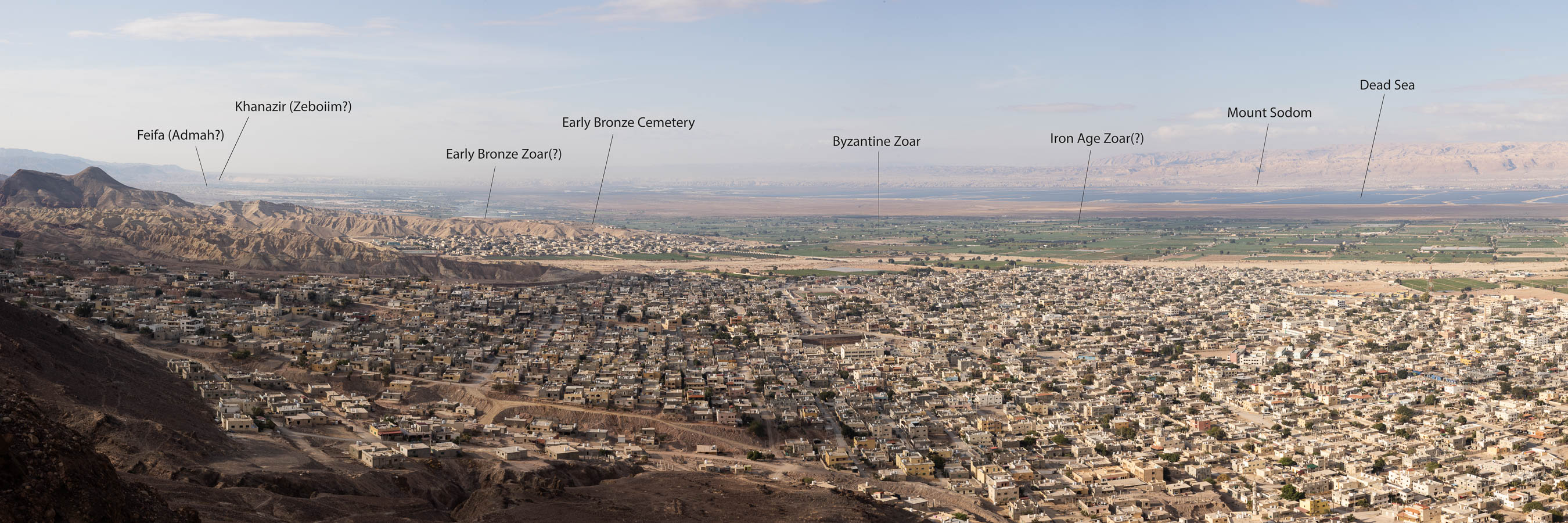
The southern end of the Dead Sea, known as the southern Ghor, as seen from a mountain above Ghor-es-Safi.
Situated 1500 feet below sea level, the southern Ghor is an unlikely place to look for a lost city. The blazing sun shines with power “sufficient to carbonize those unprotected from its fierceness.” Thus lamented the British navy lieutenant, Thomas Molyneux, who died aboard his ship shortly upon returning from an expedition to the Dead Sea. The carbonizing sun would claim the lives of other explorers as well, including young Christopher Costigan, who was found lying unconscious next to his little boat on the north shore of the Dead Sea. He died several days later in Jerusalem. Costigan’s servant, who was with him for part of that time, later recounted how they had been driven by thirst to make coffee from the water of the Dead Sea. If so, then that was undoubtedly what killed Costigan.1Jampoler 2015, 159 ff. The water of the Dead Sea contains one third dissolved minerals such as magnesium, calcium, and potassium; and roughly four times more salt than regular sea water.
Situated on an active fault line, the Dead Sea lies at the bottom of a deep gash in the earths crust. But just how far was the Dead Sea below sea level and how deep was it? Neither Costigan nor Molyneux were able to discover. Both men carried heavy lead weights attached to a line with which to measure the depth of the sea. Costigan took measurements but his notes were never recovered. Molyneux was able to take two soundings of the Dead Sea but then grew too exhausted to take more. Both Molyneux and Costigan made the fatal mistake of travelling in this region during the hot summer months and ran out of water. It may seem to us like a foolish mistake, but it is easy to underestimate how much water the body requires in the stifling heat of that region, especially when doing something active, like rowing a boat on the Dead Sea.
The depths of the Dead Sea were never fully plumbed until an expedition led by the American naval officer, William F. Lynch, conducted a survey of the region. The American expedition was well planned and well armed, and it traveled during March and April instead of August. The Americans would spend seventeen days exploring the sea on special boats outfitted with shade canopies and a large blunderbuss mounted to their bows. Despite these careful preparations, many of the sailors suffered from influenza and one died from the illness.2Jampoler 2005, 241
The numerous depth soundings made by the American expedition revealed that the Dead Sea was actually two “submerged plains,” the southern covered by 13 feet of water on average, and the northern by 1300 feet of water. They also determined the elevation of the Dead Sea using the extremely labor intensive method of establishing line of sight elevation points from the Dead Sea all the way to the Mediterranean. Their survey work proved to be quite accurate. The surface of the Dead Sea lay 1316.7 feet below sea level, making it the lowest place on earth.

The American navy captain who led an expedition down the Jordan River from the Sea of Galilee to the Dead Sea.
Early explorers to the region were not motivated solely by a desire to gain scientific knowledge. They were also drawn to the area by the Biblical account of the “five cities of the plain” which the Bible places somewhere near (or even under) the Dead Sea. All but one of these cities were reduced to ashes by the wrath of God because of their great wickedness. It was this famous account, recorded in the nineteenth chapter of Genesis, that motivated intrepid explorers to venture into what one 13th century AD traveler colorfully described as “the mouth of hell.”3Jampoler 2015, 25
The Geography of Hell
As you may recall, when Abraham offered Lot the choice of land, Lot chose to settle on the “plain of the Jordan… well watered everywhere like the garden of the LORD, like the land of Egypt, in the direction of Zoar.” (Gen. 13:10) It is difficult to conceive of this cruelly hot and arid region around the Dead Sea being in any way comparable to the famously fertile Egyptian delta, never mind the garden of Eden, but this is how it is described. The text also gives a clue as to the location of the cities of the plain—they were located on the plain of the Jordan “in the direction of Zoar.” Since Zoar is the only city of the plain which was not destroyed, and even continued to be inhabited in later periods, the question naturally presents itself: where is Zoar?
The Christian pilgrim, Egeria, who travelled through the Holy Land from 381-384 AD, may be of some assistance. This remarkable woman left many valuable observations from a time when ancient traditions were still alive. One of the places she visited was Mount Nebo, on the north end of the Dead Sea. Her description of what she saw from the top of this mountain contains some important information about the geography of the region, including the whereabouts of Zoar. The city of Livias (Tell el-Hammam), says Egeria, was visible directly below her, and Jericho on the opposite side of the Jordan. Both of these sites are located on the north end of the Dead Sea and thus not too far distant from Nebo, but “so great was the height of the mountain,” says Egeria, that many other sites were visible also.
The greatest part of Palestine, the land of promise, was in sight, together with the whole land of Jordan, as far as it could be seen with our eyes. On the left side [south] we saw all the lands of the Sodomites and Segor [Zoar] which is the only one of the five cities that exists to-day.
Her description implies that Zoar (Segor) was a considerable distance from Nebo in relation to Livias and Jericho. The only reason it was visible was due to the lofty vista afforded by the mountain. She also says that Zoar was located south of her and that it was an important site where a Byzantine church and monastery were located. During the last several decades the archaeologist, Konstantinos Politis, has excavated several churches on the southern end of the Dead Sea, at Ghor es-Safi, and also a monastery connected with a cave in the cliffs above. These undoubtedly belonged to Byzantine site of Segor—that is Zoar.
If there were any doubt on the matter, its location is also marked on a remarkable mosaic, known as the Madaba Map, which once covered the entire floor of the Church of St. George in Madaba, Jordan. Constructed in the 6th century AD, and thus several hundred years after Egeria, only portions of it remain. It nevertheless preserves a wealth of geographical information, including a map of the Dead Sea which shows Zoar located on its southern shore.4See note at bottom for further discussion of the location of cities of the plain.
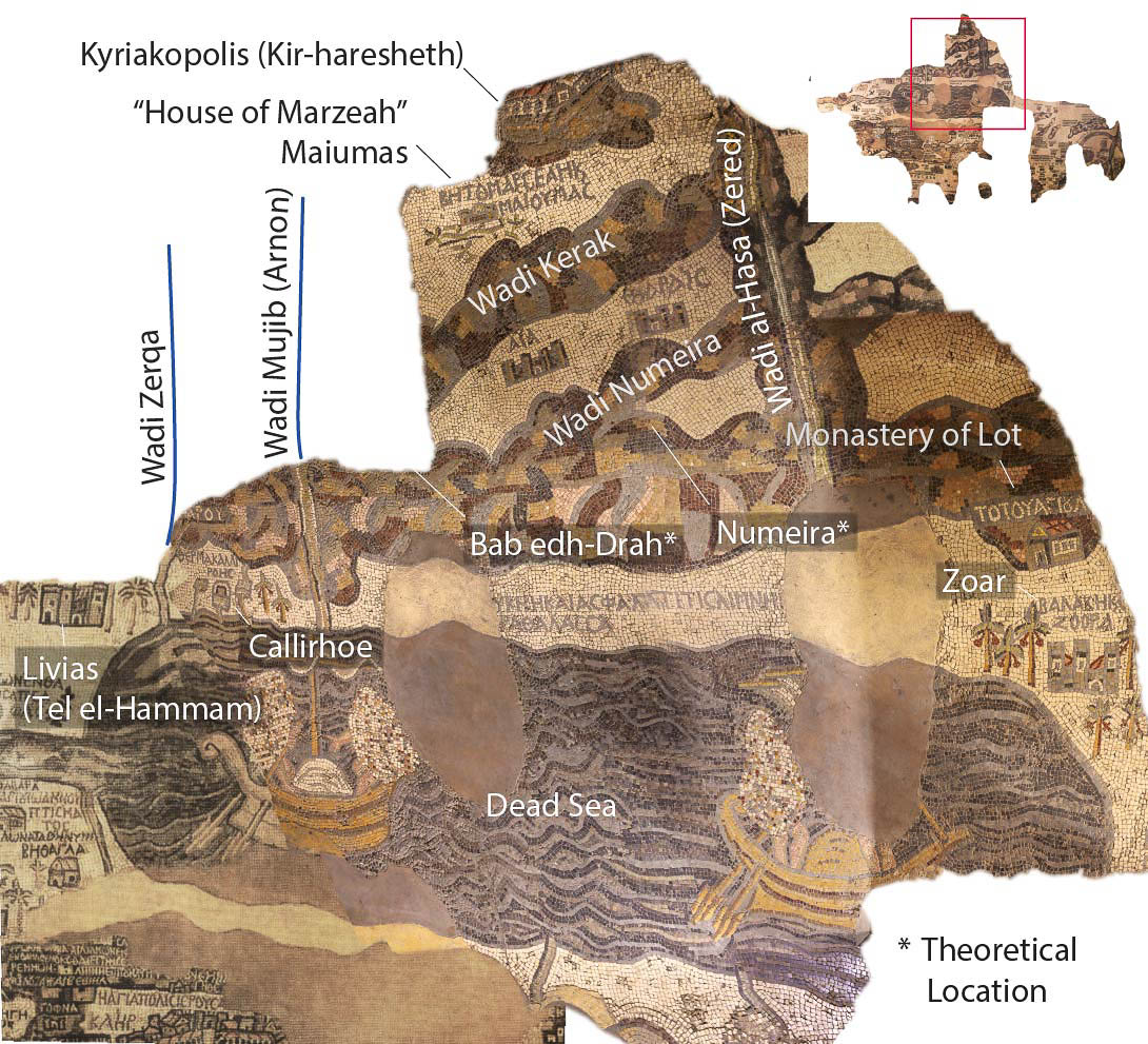
Only partially preserved, the map is made with thousands of colored stone tessarae. It shows “Balakh / Zoara” on the south eastern shore of the Dead Sea, marked by a tall building and date palms. According to Genesis, Belah was the former name of the city.
Zoar is described in Genesis as the smallest of the five cities of the plain. The names of the others are listed in Genesis 14 as Sodom, Gomorrah, Admah, and Zeboiim. These five cities are said to have been situation on a “plain” identified elsewhere as the Valley of Siddim (Sodom). In what appears to be a late scribal addendum, the Valley of Siddim is identified with the Salt Sea, as though the valley now lies beneath it (Genesis 14:3).
And all these joined forces in the Valley of Siddim (that is, the Salt Sea). (Gen. 14:3 ESV)
This is not hard to imagine since, as you may recall, one of the discoveries made by early explorers to the region is that the southern basin of the Dead Sea was a submerged plain covered by only thirteen feet of water. Today, the southern basin is almost completely dry.
Returning to our passage in Genesis, we also learn that there were numerous “tar pits” in the valley (Gen. 14:10). It is a curious detail since there is no evidence of tar pits around the Dead Sea today, but great masses of bitumen are known to occasionally rise to the surface of the Dead Sea from fissures beneath it. The Roman historian, Diodorus Siculus, tells a story about Greek soldiers who were engaged in harvesting bitumen (tar) from the surface of the sea when a group of Nabataeans launched reed boats and picked them off one by one with arrows.5Oron 2015, 74 The story illustrates the importance of bitumen to the region. It also suggests the possibility that the tar pits which were located in the Valley of Siddim according to Genesis 14:3 are now covered by the waters of the southern basin of the Dead Sea and that they are responsible for the tar that still occasionally bubbles to the surface of the sea in this area.
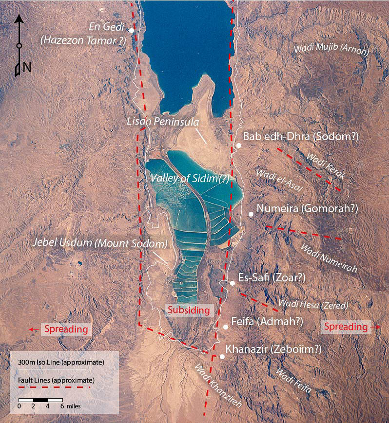
Known as the southern Ghor, the southern basin of the Dead Sea is now used for mining minerals. Notice how all the surviving archaeological sites are located east of the fault line and are, therefore, on the plate that is sliding rather than the one that is subsiding.
There are two complicating factors that make it difficult to reconstruction the topography of this region for the Early Bronze Age. Firstly, the level of the Dead Sea has fluctuated dramatically over the centuries and millennia. Returning to Egeria’s testimony, we learn that there was a pillar located six miles from Zoar, known as “Lot’s Wife” which was no longer visible since, according to Egeria, “the water now covers the whole of this space.” The bishop of Zoar nevertheless assured Egeria that the pillar had been visible in his lifetime. The most likely explanation for this is that the level of the Dead Sea had risen considerably in the period preceding Egeria’s visit and covered the geological landmark. It may be relevant to this discussion that Zoar appears very near the shore of the Dead Sea on the Madaba map whereas today it is nearly 5 miles distant. There are other indications as well that the climate of the region turned wetter during the Roman period. For instance, there is a proliferation of Safaitic inscriptions in the harrat of Jordan and Arabia which are otherwise inexplicable unless people had a reason to visit these areas for grazing or hunting, just as they did during the Early Bronze period, although not on the same scale. There is also evidence for the renewed use of desert kites for hunting gazelle in the desert. Similar observations have been made with regards to the Middle Euphrates6Hole 1996, 52 and in the Aegean where a transition to a wetter climate began around 350 BC, reaching its peak around 50 AD.7Finné and Labuhn 2023, 36; They writes, “Wetter climate conditions seem to have become more pronounced around 350 BC. The period of wetter climate conditions persists and at around AD 50 the wettest climate conditions in the period 700 BC to AD 300 occur.” Geologists who have studied the fluctuating levels of the Dead Sea point to several periods of high water, including the late Roman and early Byzantine periods.
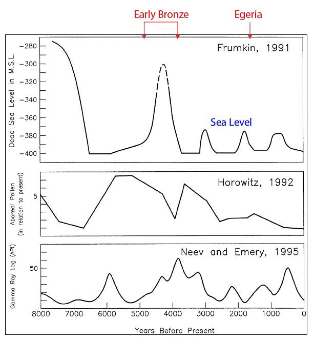
This chart shows the cyclic nature of environmental changes in the Dead Sea region.
Take these models for what you will but there can be no doubt that the level of the Dead Sea has risen and fallen considerably in the past, and this seems to be what Egeria was referring to when she noted that a certain landmark was “covered by water” in the years prior to her visit. Even so, the high sea level observed by Egeria must have been considerably lower than that which prevailed during the Early Bronze period, when the sea level was, by some estimates, as much as 100 meters higher than it is today. These high sea levels may be attributed to a considerably wetter climate.8Donahue writes, “Horowitz (1992), in an examination of pollen records for the Dead Sea region (fig. 2.8), suggests that a more humid climate prevailed in Chalcolithic and Early Bronze time with more arid conditions during EB III and especially EB IV time.” (See Jack Donahue, “Geology and Geomorphology,” in Rast and Schaub 2003, 25; see also Hole, 1996, 45.) If the level of the Dead Sea increased by even a fraction of this height during the Early Bronze period then it would seem to preclude any possibility of locating the cities of the plain beneath the southern basin of the Dead Sea. We would expect instead to find them high and dry. However, there is a second variable at work that also needs to be taken into account.
The Dead Sea lies at the bottom of a major rift known as the “Dead Sea Transform,” formed by the separation of the African and Arabian plates. As a result, the land between the plates—technically known as a graben—is subsiding. This is, of course, why the Dead Sea is the lowest place on earth. Just as equal and opposite forces have created the Himalayas. The question is, just how much subsidence has occurred in the rift valley since the Early Bronze Age? If the rate at which the graben has subsided has outpaced the falling sea levels, then it is still possible for one or more of the cities of the plain to be located beneath the present level of the Dead Sea. In which case they are probably out of reach of archaeology since they will have been deeply buried under sediment by now. On the face of it, such drastic changes to the topography of a region seem manifestly unlikely, but as we will see in our study of the Indus Valley, rapid and violent changes to the topography of a region are not unknown in tectonically active regions. Having said that, if the cities of the plain are located on the plates that are separating, rather than on the plate that is subsiding, then it may be possible to find some trace of them. We will return to this topic in our next entry.
The Battle of Siddim
One of the most interesting and historically the most important story recorded about Abraham in Genesis is the account of a great battle in the Valley of Siddim. Arrayed on one side were the five kings of the cities of the plain, and on the other, a coalition of four kings from the north.
In the days of Amraphel king of Shinar, Arioch king of Ellasar, Chedorlaomer king of Elam, and Tidal king of Goiim, these kings made war with Bera king of Sodom, Birsha king of Gomorrah, Shinab king of Admah, Shemeber king of Zeboiim, and the king of Bela (that is, Zoar). (Gen. 14:1-2 ESV)
There have been many attempts to connect these names to historical figures, or to at least place them within a chronological framework. The names themselves look authentic. Tidal, for example, looks like Tudhaliya, a well known dynastic name adopted by Hittite kings. Tidal is further identified as a king of the Goiim, a term used elsewhere in the Bible with reference to northern, Indo-European speaking peoples. This identification therefore looks solid. The same is true of Chedorlaomer, a typical Elamite name (kudur “servant of” + deity). Arioch is a name attested at Mari. Perhaps Ellasar should be identified with Ullishum, a city which is thought to have demarcated the western boundary of Naram-Sin’s empire. The city appears in the Amarna letters as Ulliza.9See discussion in Alkhafaji and Marchesi 2020, 14; also UET 1, 275.


The likely location of the Valley of Siddim situated on the southern coast of the Dead Sea. Mount Sodom is located on the opposite side of the sea. Byzantine Zoar is in the middle distance and the Early Bronze cemetery is in the foreground.
Egyptologist and Old Testament scholar, Kenneth Kitchen, argued that the context for the battle described in Genesis 14 fits best in the Isin-Larsa period that follows the Ur III.10Kitchen 2003, 319 ff. Kitchen thought it unlikely that a coalition of Sumerians, Elamites, and Hittites would attack the Transjordan during the Akkadian period, when the Akkadians are supposed to have controlled a vast territory. However, one could argue that this is exactly the period when one would expect to find such a coalition. Akkadian control over their conquered territories was tenuous, at best, and opposed by international coalitions like the one described in Genesis 14. Thus we find Sumerians and Amorites joining forces with Rish-Adad, king of Apisal, to fight against Naram-Sin in Syria.11Foster 1990, 25-48 Westenholz identifies Apishal with Armanum (Armi), noting that both cities had a king named Rish-Adad and Armanum is elsewhere identified as the most important city conquered by Naram-Sin.12 Westenholz 1997, 167 ff. Having launched his campaign from northern Mesopotamia, Naram-Sin calls upon his allies in the Upper Tigris and Subartu to honor their treaty with him and join him in battle.13Foster notes that it is not altogether clear whether Naram-Sin is calling upon his allies to attack the king of Apishal, or vice versa. His allies swear loyalty out of fear of Enlil. See Foster 1990, 33 for a translation of the first pericope and discussion on pp. 34-35.
As noted previously, the records we have for the Great Revolt which occurred during Naram-Sin’s reign describe a rebellion that encompassed the whole of the Ancient Near East, from Purushanda in Anatolia to Meluhha in the Indus Valley. Although Naram-Sin successfully put down the rebellion, another occurred in the days of Naram-Sin’s son, Shar-Kalli-Shari, which likewise encompassed “the four quarters” of the Akkadian empire and seems to have been more successful. Akkadian power was greatly diminished in the region as a result.14Hamblin 2006, 100 Although these wars appear to have largely passed over Canaan, it may be that the battle described in Genesis 14 represents a microcosm of the internecine strife which prevailed during the last years of the Akkadian empire. There is no other period in the history of the Ancient Near East when Elamites, Sumerians, Amorites, and Hittites can be found fighting alongside each other as allies!
One Good Man
The five cities of the plain were defeated by the coalition of four kings from the north in the Valley of Siddim. As a result, Lot and his kin were carried away as plunder. (Gen 14:10-12) Abraham pursued the attackers with a force of 318 of his own men and an unspecified number of Amorite allies, overtaking and defeating them somewhere near Dan, in northern Israel. Having returned Lot and his family to their homes, he refused to take any portion of the spoil, choosing instead to give it to a mysterious figure named Melchizedek (“King of Righteousness”), a priest of El Elyon (“God Most High”) at Salem. This is quite certainly a reference to Jerusalem.
Abraham is depicted in these verses as a mighty man, but unlike Lamech, who boasted to his two wives that he killed a youth for insulting him, Abraham’s power is tempered by integrity and kindness. The vain boasting which permeates Akkadian royal inscriptions and literature finds no place here.
We are also surprised to discover that the tribes of Hittites, Amorites, and Jebusites living in Canaan at the time, were friends and allies of Abraham, even though they will later appear as the sworn enemies of his descendants. These complexities and apparent contradictions give the account of Abraham’s life an air of authenticity.
Albright, William F. “The Archaeological Results of an Expedition to Moab and the Dead Sea.” Bulletin of the American Society of Overseas Research 14 (April 1924). Link
Hole, Frank.
“Evidence for Mid-Holocene Environmental Change in the Western Khabur Drainage, Northeastern Syria,” in Third Millennium BC Climate Change and Old World Collapse, edited by H. N. Dalfes, H. N. Kukla, H Weiss.
Berlin / Heidelberg: Springer , 1996.
Jampoler, Andrew.
Sailors in the Holy Land : the 1848 American Expedition to the Dead Sea and the Search for Sodom and Gomorrah.
Annapolis, Md.: Naval Institute Press, 2005.
Lapp, Paul, Thomas Schaub, Walter Rast.
Bāb edh-Dhrāʻ : Excavations in the Cemetery directed by Paul W. Lapp (1965-67).
Winona Lake, Indiana: Eisenbrauns, 1989. Link
Lapp, Paul. “Bâb Edh-Dhrâ’ Tomb a 76 and Early Bronze I in Palestine.” Bulletin of the American Schools of Oriental Research, no. No. 189 (1968): 12–41. Link
Oron, Asaf, Ehud Galili, Gideon Hadas, Micha Klein. “Early Maritime Activity on the Dead Sea: Bitumen Harvesting and the Possible Use of Reed Watercraft.” Journal of Maritime Archaeology 10, no. 1 (2015): 65–88. Link
Rast, Walter, Thomas Schaub.
Bāb edh-Dhrāʻ : Excavations at the Town Site (1975-1981).
Winona Lake, Indiana: Eisenbrauns, 2003.
Rast, Walter E.Archaeology 40, no. 1 (1987): 42–49. Link
The cities of the plain are five: Sodom, Gomorrah, Admah, Zeboiim, Bela (Zoar). Some scholars have preferred to locate these cities north of the Dead Sea. However, the Bible clearly places them on the furthest edge of the Jordan Valley, hence its use of the descriptive phrase “as far as Sodom” or “as far as Zoar”( cf. Gen. 13:12, Deut. 34: 3). It would not make sense to use this phrase if Zoar lay at your feet (in the case of Moses on Nebo) or if Sodom were just across the Jordan (in the case of Abraham and Lot standing above Ai).
If the cities of the plain were located north of the Dead Sea then we should expect Jericho to be numbered among them since it was certainly the most prominent city in the area. But Jericho is never included with the five cities of the plain. Zoar and Jericho are mentioned together in Deuteronomy 34:3 but only to emphasize the distance between them.
Zoar is certainly located south of the Dead Sea as all of the ancient sources attest, including Josephus, Eusebius, Egeria, and the Madaba map. There are several other clues which suggest that the other four cities of the plain should also be located in the region south of the Dead Sea. Firstly, Sodom is said to have been located near Zoar, within easy walking distance, since Lot and his family fled there in the night. Sodom should also be within walking distance of Mamre since the angels, having appeared to Abraham, arrived at Sodom by evening. I have walked from the outskirts of Hebron to Ein Gedi, on the western shore of the Dead Sea, in a day without trouble; the journey to Sodom would be a full day, its length depending primarily on how far one had to walk around the southern end of the Dead Sea or if there was a ferry.
Secondly, the Bible uses the cities of the plain to mark the southernmost border of Canaan, which is described as having extended from Gaza on the coast eastwards to the cities of the plain “as far as Lasha.” (Gen 10:19) If Sodom and the other cities of the plain were located north of the Dead Sea, one would have to move the southern boundary of Canaan northwards, cutting off important territory which we know was a part of the tribal allotment of Judah.