Geography without History seemeth a carkasse without motion, so History without Geography wandreth a Vagrant without certaine habitation.1From the Introduction to Land Behind Baghdad by Robert McC. Adams
John Smith, General Historie of Vierginia, 1624
Our history begins in the Middle East, in the region known today as the Fertile Crescent, a land of high plains and fertile valleys, encompassed about by mountains, desert, and sea. Its crescent shape is determined by the mountains and the sea and also by the 8 inch (200 mm) isohyet—a theoretical line which maps average rainfall (Greek. iso “equal,” huetós “rainfall”). As a general rule, a cereal crop cannot reliably be grown on land which receives less than 8 inches (200mm) of rain per year. Land which receives 4 inches (100mm) or less on average is classified as desert. The land inside the hollow formed by the Fertile Crescent is therefore known as the Syrian Desert.
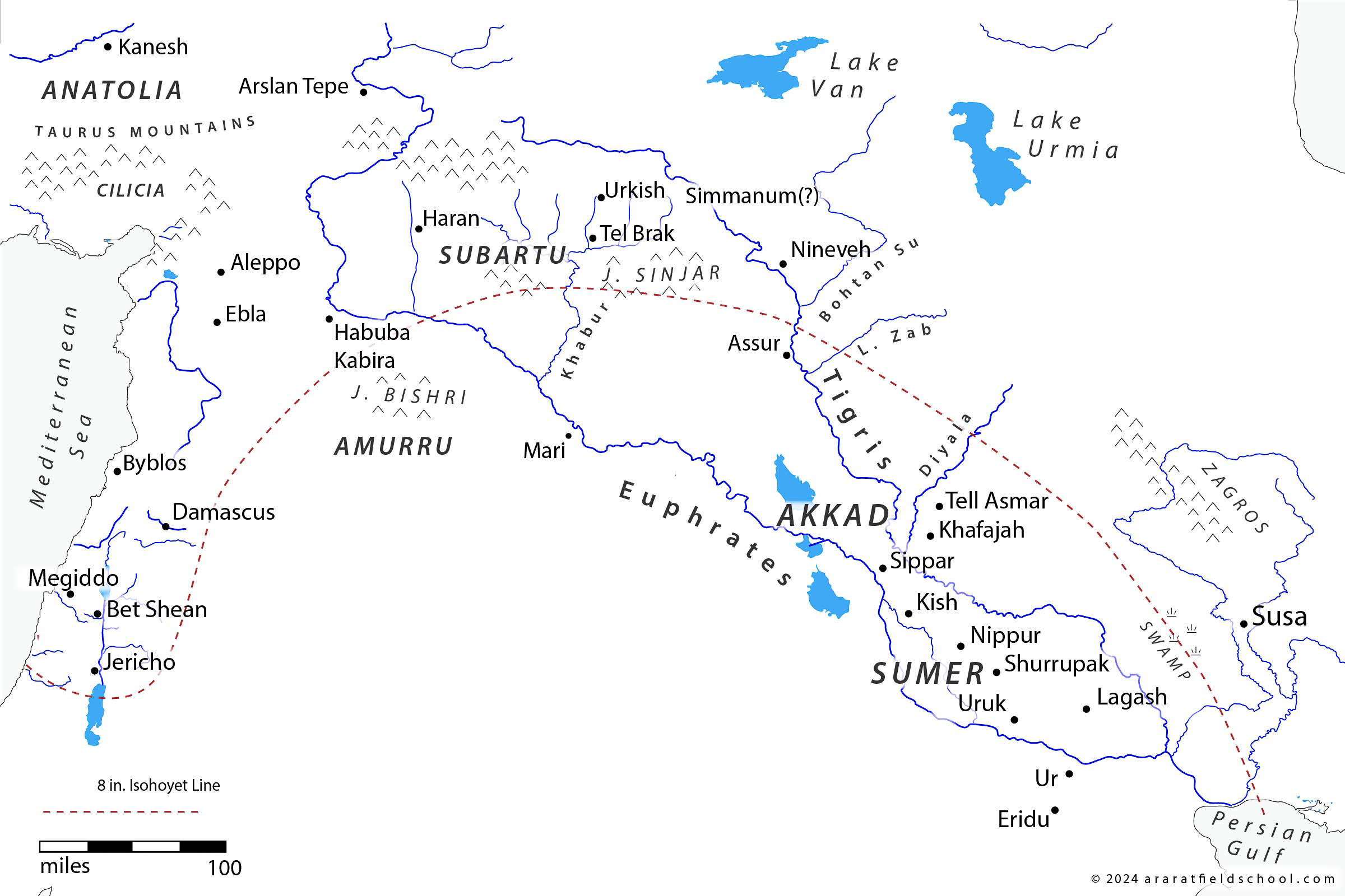
Land above the 8″ ishoyet line may generally be relied upon to produce a harvest. In recent years this line has shifted back and forth 150 miles or more over the course of just several decades (see here).
The fertility of the Fertile Crescent comes from the rich sediment (alluvium) deposited by rivers into valleys and flood plains. Farming appears to have begun in the smaller alluvial valleys situated in the mountains, where wild varieties of wheat and barley were readily available for domestication. But early farmers must have soon realized the potential represented by the vast alluvial plain which stretched out beneath them, formed by the Tigris and the Euphrates rivers. Although the region between the two rivers lies below the 8 inch isohyet line, and is therefore technically a semi-arid desert, it is supplied with ample water for irrigation. The farmers who moved onto this vast alluvial plain, known as Mesopotamia (Greek “between the rivers”), would eventually coalesce to form the Sumerian civilization. They were the first to produce writing, live in cities, and grow surpluses of grain that could be stored away for future use. Our history naturally begins with them.
Climate
There has been a tendency in recent years to downplay the effect of climate change on the history of the ancient world. The underlying assumption is that the earth’s climate has been relatively static and only in recent years has it begun to experience dramatic change due to the burning of fossil fuels.2Carney 2021, 262; Carney writes, “Since the last ice age, the human race has thrived over an 11,000 year era of extraordinary climate stability—the Holocene. Now that stability is shattering.” Renfrew and Bahn, for example, in their classic textbook on archaeology argue that temperatures for “the last 10,000 years have been stable apart from the Little Ice Age in the early Middle Ages.”3Renfrew and Bahn 2008, 232 The Little Ice Age referred to by Renfrew and Bahn is generally thought to have prevailed from 1350 AD until 1850 AD. The unusually cold temperatures experienced during this period have been captured in several famous paintings, such Bruegel’s The Hunters in the Snow and Thomas Wykes’ The Frost Fair. However, what is sometimes overlooked is that Little Ice Age was preceded by the Little Climatic Optimum, a period of unusually warm temperatures. (Or maybe the earth’s climate is not as static as we think?)

Paintings of wintery landscapes such as this one by Peter Bruegel (1526-1529) point to a more wintry climate in Europe.
In his history of the westward expansion of the Vikings, Farley Mowat suggests that average temperatures along the southern coast of Greenland were 2 to 4 degrees warmer during the Little Climatic Optimum than they are at present. Rising sea temperatures brought the white-beaked dolphin and the pilot whale off the coast of southern Greenland where their bones have been found in Viking settlements. That the environment of Greenland was once more hospitable to life than it is now is indicated by a cemetery connected to one of the Viking settlements excavated by archaeologists. The earliest burials in the cemetery are quite deep—evidently the land was fully thawed during the summer months. In contrast, later burials were on the surface—apparently cut from the permafrost with some difficulty.4Mowat 1990, 384-388

The last written evidence of a Viking presence on Greenland is a record of a wedding that took in this church in 1408.
The Little Climatic Optimum of the Middle Ages may be compared to another, more famous period of climate change known as the Holocene Climatic Optimum (HCO), which has generally been dated by climatologists from c. 9500 to 4500 BC (but see below). Also known as the African Humid Period, it was marked by an increase in rainfall globally. As a result, forests grew on the dry plains of Iberia and Central Asia and the band of desert which today extends from Africa to Pakistan turned into green savannah. India is also thought to have been enveloped in a lush tropical forest during this period.5Brooke 2014 The HCO raises many interesting questions: What caused this period of increased rainfall? Was it a period of warmer or cooler temperatures? When did it begin? And when did it end? The latter question is especially relevant to our present study, for if the HCO ended around 4500 BC, as is generally thought, then it cannot have much bearing on the Early Bronze period, which does not begin for another millennium. However, the evidence suggests that the end of the HCO should be moved forward several millennia, to around 2500 BC, which brings it well within the Early Bronze period. I would argue that, just as the Viking settlements on Greenland cannot be understood apart from the warmer climate which prevailed there during the Middle Ages, neither can the settlement patterns of the ANE apart from the wetter climate that prevailed in the region for most of the Early Bronze period.
Regions
We will have more to say about climate and geography as we continue. For now, it will be helpful to familiarize yourself with the following terms and regions displayed on the map below.
- Ancient Near East – The Near East and the Middle East may be used interchangeably to refer to the geographical region which lies between Asia and Europe. It encompasses Anatolia and Iran from west to east, and Arabia and the Caucasus from south to north.
- Levant – This French word is derived from the Latin levare which means “rising.” It was originally used to refer to all of the lands in the East from the perspective of a European. The term is now limited to the region of the Mediterranean coast that encompasses the modern states of Cyprus, Lebanon, Syria, Israel, and Jordan. The Levant may be further divided into a northern part, “Syria,” and a southern part, which falls under the broad designation, “the southern Levant.”
- Anatolia – This word has the same general meaning as “Levant,” but it is derived from Greek instead of Latin. It is used today to refer to that region which belongs today to the modern state of Turkey.
- Mesopotamia – Greek for “Between the Rivers” this term is used to refer to the region between the Tigris and the Euphrates, in what is today Iraq.
- Caucasus – A mountainous region between the Black and Caspian seas, it is an important land bridge between Europe and Asia. Of uncertain derivation, the term has been linked alternatively to “mountains” (Greek. kasos) or “snow” (Scythian, croucasis) although other etymologies are possible.


It will be helpful for you to familiarize yourself with the following regions covered in this course.
Brooke, John L.
Climate change and the Course of Global History : a Rough Journey.
Cambridge: Cambridge University Press, 2014.
Carney, Mark.
Value(s).
United States: Signal, 2021.
Hole, Frank.
“Evidence for Mid-Holocene Environmental Change in the Western Khabur Drainage, Northeastern Syria,” in Third Millennium BC Climate Change and Old World Collapse, edited by H. N. Dalfes, H. N. Kukla, H Weiss.
Berlin / Heidelberg: Springer , 1996.
McC. Adams, Robert.
Land Behind Baghdad: A History of Settlement on the Diyala Plains.
Chicago, Ill: University of Chicago, 1965. Link
Renfrew, Colin, Paul Bahn.
Archaeology: Theories, Methods, and Practice.
New York: Thames & Hudson, 2008.