
Known in the New Testament as the Sea of Galilee, its more ancient name was Kinneret, after the tell located on its northwestern shore names “Kinnerot” in Egyptian texts of the Late Bronze Age. Bet Yerah, by this time, had ceased to exist.
The Sea of Galilee is the largest body of sweet water in the Levant and home to many different species of sardine, carp, and tilapia. Its more ancient name is Kinneret, transliterated “Genneseret” by the Greeks, a name which will already be familiar to readers of the New Testament. The Sea of Galilee falls into a unique climate zone where the Mediterranean coastal climate meets the continental “Irano-Turanian.”1Greenberg 2014, 1-4 The region was, according to the Jewish historian Josephus (1st century AD), a veritable garden of Eden where every kind of fruit and vegetable could be grown.
The country also that lies over against this lake hath the same name of Gennesareth; its nature is wonderful as well as its beauty; its soil is so fruitful that all sorts of trees can grow upon it, and the inhabitants accordingly plant all sorts of trees there; for the temper of the air is so well mixed, that it agrees very well with those several sorts, particularly walnuts, which require the coldest air, flourish there in vast plenty; there are palm trees also, which grow best in hot air; fig trees also and olives grow near them, which yet require an air that is more temperate. One may call this place the ambition of nature, where it forces those plants that are naturally enemies to one another to agree together; it is a happy contention of the seasons, as if every one of them laid claim to this country; for it not only nourishes different sorts of autumnal fruit beyond men’s expectation, but preserves them a great while; it supplies men with the principal fruits, with grapes and figs continually, during ten months of the year 1 and the rest of the fruits as they become ripe together through the whole year; for besides the good temperature of the air, it is also watered from a most fertile fountain. The people of the country call it Capharnaum.2Josephus, Jewish War, translated by William Whiston, 3.10.8 (516 ff.)
Herod Antipas constructed a city on its western shore in 20 AD, which he named Tiberius after the reigning Roman emperor. The same Herod had John the Baptist put to death and participated in the trial of the Lord Jesus. But long before Herod and the Romans, another city flourished on the southern shores of Kinneret. Known today by its Arabic name, Khirbet el-Kerak (“Ruins of the Castle”), its ancient name, Beth Yerah, means “House of the Moon.” The city was constructed on a peninsula formed by the sea and an ancient channel of the Jordan River, which now exits further to the south.
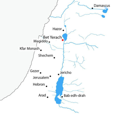


The region was named Kennartou in Egyptian texts of the New Kingdom period, and Kinneret in the Bible (Jos. 13:27).
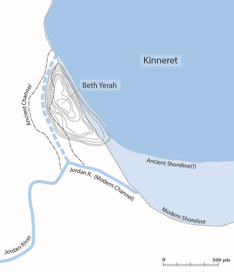
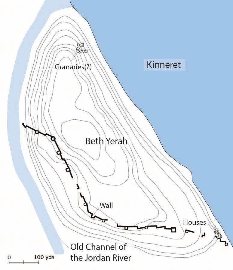
At its height, the site probably covered around 75 acres.1Greenberg 2014, 9 The Jordan River exited the Sea of Galilee further to the north than it does today, and flowed parallel to the sea, creating a highly defensible peninsula that was approachable only from the south. The southern shoreline has moved south over the millennia due to wave action created by the prevailing northerly winds.
Initial excavations were conducted by a group of Israeli archaeologists led by Benjamin Maisler (Mazar) between 1945-1946. Sporadic excavations have continued since then, most recently conducted by a team from the Tel Aviv University led by Raphael Greenberg. The discovery of Grey Burnished Ware in the lowest levels of the city suggests that the site was already occupied in the Early Bronze I period. It was fortified with a mudbrick wall during the Early Bronze II period. This wall was replaced with another mudbrick wall, constructed on basalt stone foundations, during the Early Bronze III.3Maisler et al. 1952, 172 The design of the wall, with its projecting towers positioned at regular intervals, resembles the walls of Arad.
The Circles Building
Maisler and his team made an outstanding discovery in 1946; a large platform constructed of basalt approximately 130 feet long by 100 feet wide.
Nine circular depressions, approximately 4 inches deep and 30 feet in diameter, were incorporated into the perimeter of the platform. The circles were divided into quarters by interior walls, arranged like the spokes of a wheel, but missing the hub. In all likelihood, the circular depressions formed the foundations for a beehive-shaped structure made of mudbrick. The four interior walls were required to provide support to the “dome” of the beehive structure. The reason the interior walls do not meet in the middle is undoubtedly because the structure had a circular opening at the apex of the dome which the builder wanted to be able to access from inside. The purpose for the 4 inch circular indentation was likely to prevent the walls from pushing outward due to the weight of whatever it was that was stored inside the structure (see below).

This complex was constructed on massive stone foundations, requiring significant planning and resources.
The excavators of the basalt platform with its circular indentations, interpreted it as a temple complex. However, it is now generally agreed that they were granaries, each capable of holding approximately 6000 bushels of barley.4Mazar 1992, 127 Traditionally, a bushel was measured using a large willow basket 18 inches in diameter and 12 inches deep. When filled with barley, the basket weighs around 50 pounds, which is the amount a man can comfortably carry. A bushel of wheat weighs slightly more. Thus, according to one estimate, the nine granaries at Bet Yerah held approximately 1400-1700 tons of grain.5Mazar 1992, 127
Beehive shaped granaries are known from Egypt. Petrie found quite a large number of them at Kahun, in Middle Egypt, each measuring approximately six feet in diameter, made from mudbrick, and plastered inside and out.6Kemp 2006, 217 Larger beehive granaries are depicted on a wall fresco from Thebes and terracotta models of beehive granaries have been found in Egyptians tombs.7See below and also illustrations in Currid 1985
Nothing of the granary’s superstructure remains Bet Yerah. This led Greenberg et al. (2017) to suggest that the granaries were never completed and the project abandoned, around the beginning of the Early Bronze III period. It seems to me that, given the wet climate of the Galilee, if the basalt platform remained exposed to the elements for any period of time after it ceased to function as a granary, then the mudbrick likely eroded away completely. Since the platform appears to have been repurposed at some point (see next entry), it would have been scoured by the rain, erasing all evidence of the granaries erected on it.
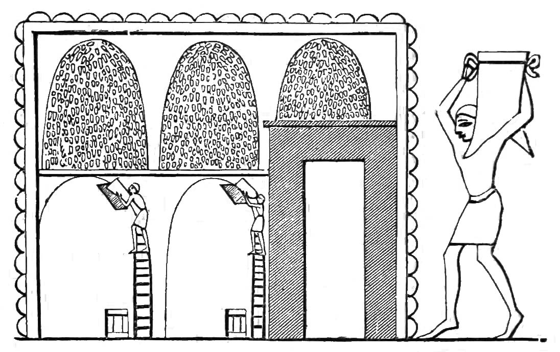

Judging by their size in relation to the workers filling them, Egyptian granaries could reach heights of fifteen feet or more. The granaries were filled by a hatch in the roof. Another hatch at the bottom was used to remove the grain.
How to Store Grain
There are two primary ways of storing grain: sealed and ventilated. The advantage of a sealed granary is longevity; grain stored in this manner may last 50 or even 100 years depending on the type of grain.8Boyles, Grain Storage in Iron Age Britain Both methods of grain storage are discussed by the Roman author, Marcus Terentius Varro (116–27 BC), in De re rustica (“On Agriculture”),
Some use underground caves as granaries, the so‑called sirus, such as occur in Cappadocia and Thrace; and still others use wells, as in the Carthaginian and Oscensian districts in Hither Spain. They cover the bottom of these with straw, and are careful not to let moisture or air touch them, except when the grain is removed for use; for the weevil does not breed where air does not reach. Wheat stored in this way keeps as long as fifty years, and millet more than a hundred. Some people, as in Hither Spain and in Apulia, build granaries in the field, above ground, so constructed that the wind can cool them not only from the sides, through windows, but also beneath from the ground.9Boyles, Grain Storage in Iron Age Britain
The key to underground grain storage was to seal the pit tight so that no air could enter. Grain pits were often bell shaped so that they could be sealed at the neck. They also took the form of open rectangular pits which were filled and the covered by a thick layer of earth. The Hittites utilized this method at Alacahoyuk and Hattusa. Once sealed, a small amount of spoilage will occur on the surface of the pit, but the process of decay quickly consumes whatever oxygen is left in the pit and replaces it with carbon dioxide, thereby creating an anaerobic environment. Not even the weevil can survive in these pits.10Boyles, Grain Storage in Iron Age Britain Other examples of anaerobic environments are peat bogs and river beds, which is why both have produced excellently preserved bodies and weapons.
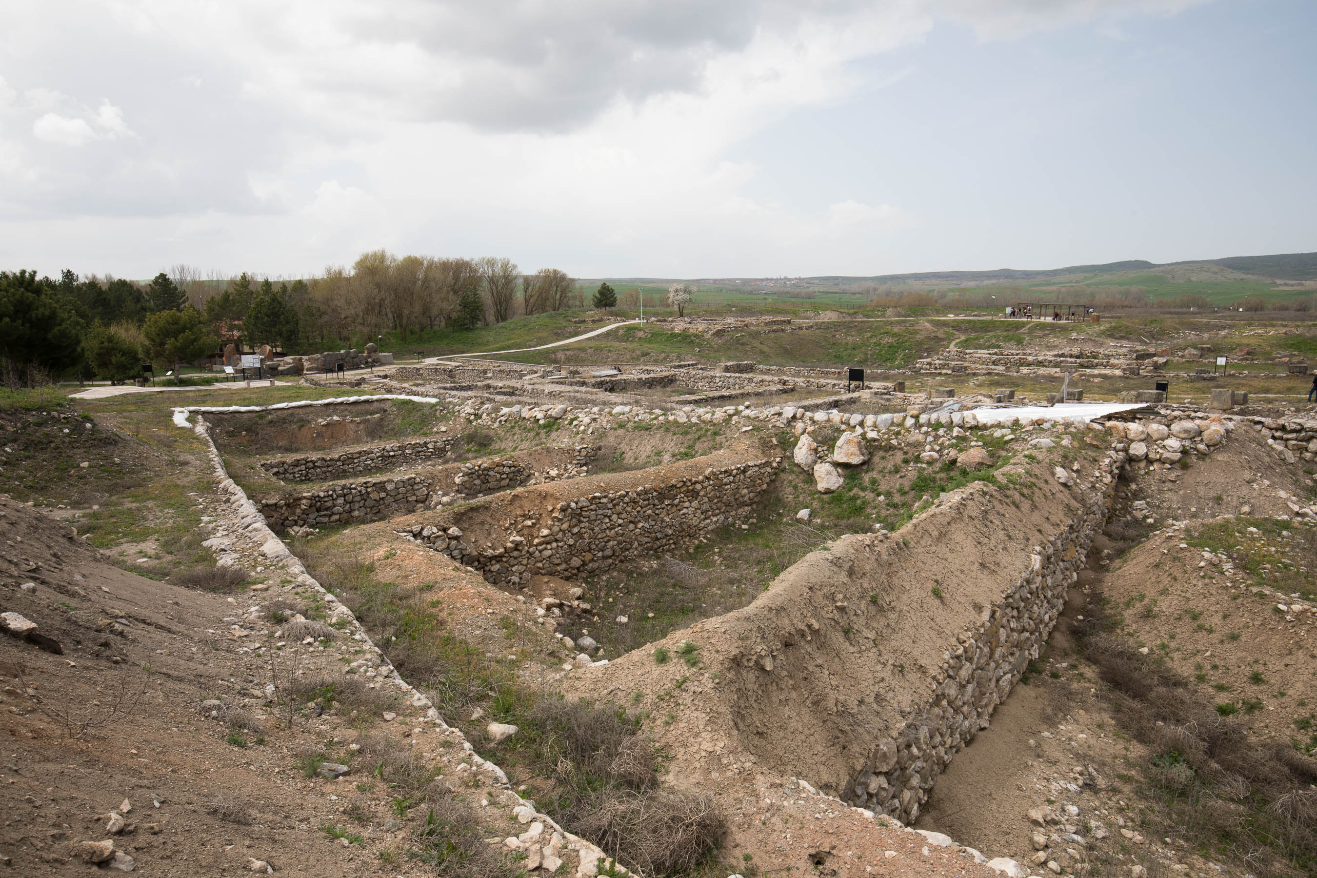
These rectangular pits were used by the Hittites at Alacahoyuk (13th century BC) to store grain. The pits were covered with a thick layer of earth. Grain stored in this way will last for many years.
Unfortunately, the underground method of grain storage is impractical for daily needs. Opening a grain pit is a difficult task and, as Varro warned his readers, it can be dangerous. As noted previously, grain pits were filled with carbon dioxide. This odorless and colorless gas was liable to asphyxiate anyone who descended into the pit before the gas had a chance to dissipate.
The beehive granary incorporated many of the advantages of a grain pit while also solving the problem of accessibility. Its solid mudbrick walls effectively kept out air and moisture, and though it was not possible to hermetically seal off a beehive granary like you could a well or pit, its beehive shape (the inverse of the bell shape) ensured that the amount of surface area exposed to the air was minimal. Grain was added through a hatch at the apex of the granary and taken from another at its base. It was a beautiful compromise, the secret to every good design.
“Grain Storage in Iron Age Britain.” LacusCurtius. May 26, 2025. Link
Currid, John D. “The Beehive Granaries of Ancient Palestine.” Zeitschrift Des Deutschen Palästina-Vereins 101, no. 2 (1985): 97–110. Link
Currid, John D. “The Beehive Buildings of Ancient Palestine.” The Biblical Archaeologist 49, no. 1 (1986): 21-24. Link
Greenberg, Raphael, Sarit Paz, Rafael Greenberg. “An EB IA–EB III Stratigraphic Sequence from the 1946 Excavations at Tel Beth Yeraḥ.” Israel Exploration Journal 54, no. 1 (2004): 1–23. Link
Greenberg, Raphael, Sarit Paz.
“The Formation of the Mound of Bet Yeraḥ,” in Bet Yerah: The Early Bronze Age Mound II : Urban Structure and Material Culture 1933-1986 Excavations, edited by Raphael Greenberg.
: Israel Antiquities Authority, 2014.
Greenberg, Raphael, Hai Ashkenazi, Sarit Paz, Mark Iserlis. “The Circles Building (Granary) at Tel Bet Yerah (Khirbet el-Kerak): A New Synthesis (Excavations of 1945–1946, 2003–2015) .” Bulletin of the American Schools of Oriental Research (2017).
Greenberg, Raphael, Ron Shimelmitz, Mark Iserlis. “New evidence for the Anatolian origins of ‘Khirbet Kerak Ware people’ at Tel Bet Yerah (Israel), ca 2800 BC.” Paléorient 40, no. 2 (2014): 83-201. Link
Kemp, B. J.
Ancient Egypt : Anatomy of a Civilization.
New York: Routledge, 2006. Link
Maisler, B, M. Stekelis, M. Avi-Yonah. “The Excavations at Beth Yerah (Khirbet El-Kerak) 1944-1946.” Israel Exploration Journal 2, no. 4 (1952): 218–29. Link
Maisler, B, M. Stekelis, M. Avi-Yonah, M. Steklis. “The Excavations at Beth Yerah (Khirbet El-Kerak) 1944-1946.” Israel Exploration Journal 2, no. 3 (1952): 165–73. Link
Mazar, Amihai.
Archaeology of the Land of the Bible.
New York: Doubleday, 1992.
Wheeler, Sir Mortimer.
“The Indus Civilization,” in The Cambridge History of India.
Cambridge: The University Press, 1953.