Situated on the lower stretches of the Indus River, in the Sind province of Pakistan, Mohenjo-daro is separated from Harappa by almost 400 miles. The material culture of the two cities is nevertheless identical. At its height, Mohenjo-daro was estimated to have occupied between 250 to 500 acres and therefore on par with the largest cities of Elam and Mesopotamia.1Allchin and Allchin 1997, 156 The grid layout of its major throughfares will not be seen again until the 7th–6th centuries BC, when the Milesian architect, Hippodamus, introduced the grid system for laying out Greek colonies. Of course, the grid system is only practical for laying out new cities when the architect has control over city planning from inception. It may be wondered, therefore, if Mohenjo-daro was not founded by a people already familiar with city-building, like what we saw with Mari.
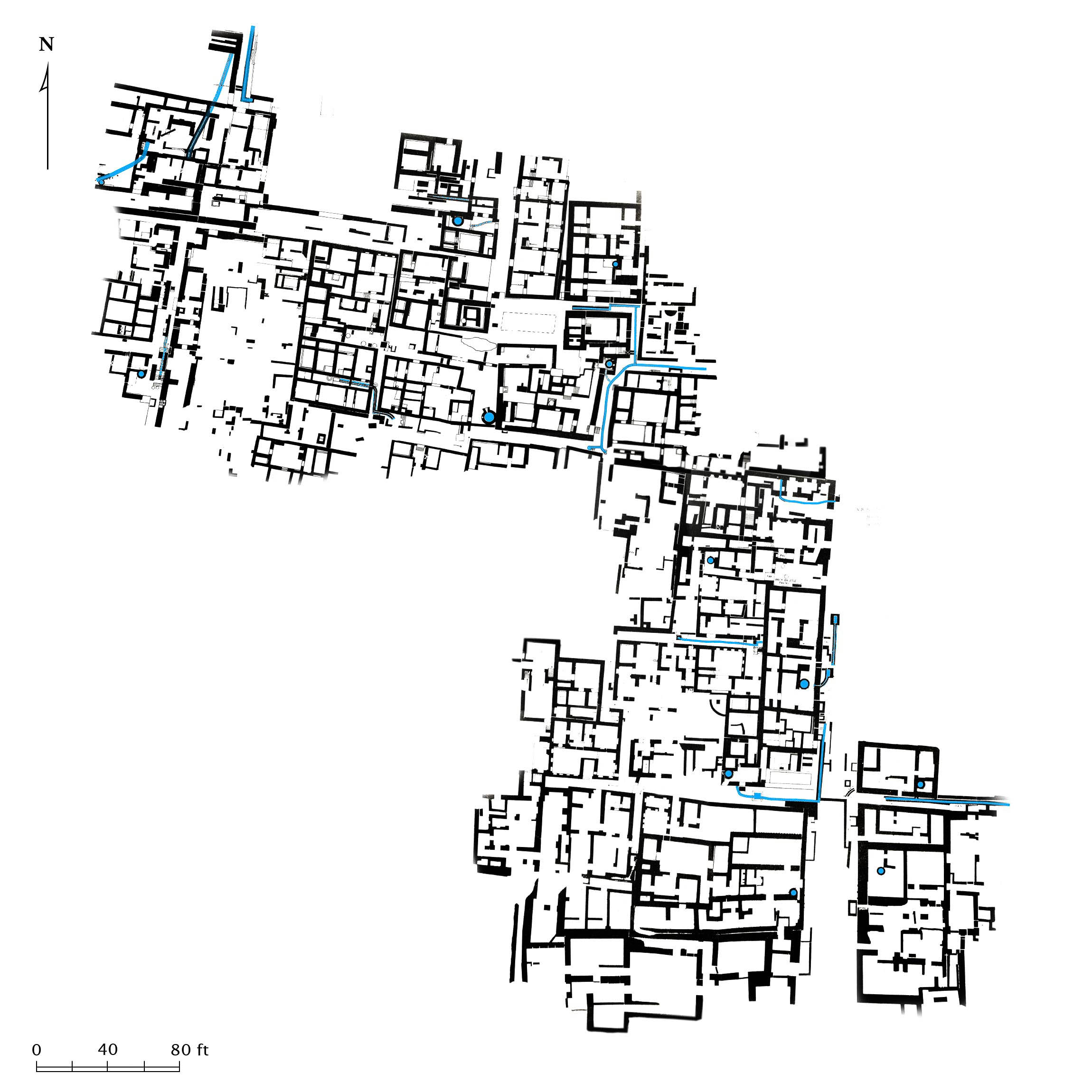
The city was loosely laid out on a grid. Blue marks water channels, basins, and wells. This was just one district of the city.
The Curious Case of a Rapidly Rising Floodplain
Besides Mohenjo-daro, very few Indus Valley settlements have been found on the plain of the Indus.2Allchin 1984, 447 This is unsurprising, for as Mallowan observed in Mesopotamia, archaeological surveys in river valleys are bound to return skewed data since most sites will be deeply buried. Sediment typically accumulates on a major flood plain at a rate of five or six feet per millennium, if one assumes a constant rate of accumulation.3Raikes 1984, 458 But the rate of accumulation in the Indus Valley was not constant. Drill cores have found evidence of occupation at Mohenjo-daro 55 feet below the present level of the plain. If the city was founded c. 2300 BC and abandoned c. 1500 BC, then the plain had to rise 55 feet over the course of approximately 800 years.4These are the figures used by Raikes. According to Raikes, most of the 55 feet of sediment was deposited during the 800 years in which the city was occupied. Giosan et al. (2012) likewise suggest that the rate of sedimentation was three times higher during the Early Bronze period than today. It seems, therefore, that the rate of accumulation was far more rapid in ancient times than today.
What caused sediment to rapidly accumulate in the 3rd millennium BC and taper off in the 2nd? The most obvious explanation is that the region received more rain during the Early Bronze period which resulted in higher floods. This was the view held by all of the early explorers and archaeologists who worked in the region, including Stuart Piggot, Mortimer Wheeler, Sir John Marshall, and Sir Aurel Stein.5V. N. Misra, “Climate, a Factor in the Rise and Fall of the Indus Civilization, Evidence from Rajasthan and Beyond,” in Lal and Gupta 1984, 474 The various types of evidence which point to higher rainfall in the region may be summed up as follows:
- Fired bricks were used exclusively in the walls and main buildings of the citadel.
- City builders made extensive use of drainage channels.
- Forests of trees were required to fire the bricks used to build Harappan cities
- Jungle animals are commonly depicted on Indus stamp seals whereas animals of the open country, such as the lion, are absent.
- Extensive settlements have been found in the arid hills of Baluchistan
The last point is worth considering in more detail. The hill country northwest of the Indus Valley falls within the province of Baluchistan in Pakistan. Traditionally inhabited by small groups of pastoral nomads, it was home to cities of considerable size during the Early Bronze period.6Wheeler 1962, 7 When considered in light of the other factors listed above, there is a strong case to be made for a wetter environment in the region during the Early Bronze period. This is in accordance with the evidence from other parts of the Ancient Near East, which also points to a wetter climate.
It wasn’t until the 1960’s that researchers began to push back against the idea that the climate of the Indus Valley was much different than it is today. Raikes and Dyson published a paper in 1961 which sought to prove that conditions in Baluchistan and the Indus Valley were essentially unchanged since Harappan times7Raikes and Dyson 1961, 279 Here is a summary of their arguments:
- The ancient population in Baluchistan may be overestimated since we do not yet have a good understanding of the chronology of the region; many settlements may not have been contemporary.
- The city mounds may have belonged to migratory populations who had a house in the mountains and another in the plain.
- Although most of the bricks were fired, not all of them were. Some of the houses were made with a mix of fired and sun-dried mudbrick
- Jungle animals could have lived along the margin of the river where forests grew.
- The forests which grow in the Indus Valley today were sufficient to fire the bricks used to build the cities.
- The drainage channels in the cities were not large enough to effectively flush water produced by a storm out of the city.8Raikes and Dyson 1961
With regards to the rapid build-up of sediment in the valley, Raikes proposed an earthquake that lifted a block of the earth’s crust resulting in a partial damming of the Indus River.9Raikes 1984, 459 Sediment would have rapidly accumulated in the depression behind the dam. Although not of the same magnitude, an event of this type occurred in 1819 when an earthquake created a 20 foot high by 50 mile long embankment known as the Allah Bund (“Embankment of God”) that dammed the Nara river. The event illustrates the potential for earthquakes to shape the environment, but it seems to me that Raikes broader argument fails the test of Occam’s razor—do not multiply hypotheses needlessly.
Further light on the subject comes from a paper published by Giosan et al. 2012 which we cited in the previous entry. The authors argue that the rate of accumulation of sediment in the Indus Valley before 700 BC was three times higher than it is today. The declining rate of sedimentation in recent millennia is due to the action of the river, which has cut a deep channel over the ensuing centuries, making flooding events less common. Normally the cutting action of the river (incision) is compensated by the deposition of silt (aggradation). However, most of the volume of the Indus today comes from snowmelt which does not contain a lot of sediment. Giosan argues that in Harrapan times the monsoons were much more active, resulting in more rainfall and elevated levels of sedimentation.10Giosan et al. 2012, E1692 Since the Indus did not flow in a deep channel, flooding events would have been more common and probably not so catastrophic. No doubt the Harappans relied upon the freshly deposited sediment to fertilize their fields, just as the Egyptians did.
Clearly the builders of Mohenjo-daro were expecting floods, which must have come at regular enough intervals to justify the construction of a 43 foot wide fired brick embankment around the city.11Wheeler 1962, 28 The city essentially grew up with the rising floodplain.
City of Water
One of the outstanding monuments in the city was the Great Bath—a large pool whose exact function is unknown. The bricks used to construct the bath are of a standard size, well fired, and bonded together with waterproof gypsum mortar. The bricks were backed by a one inch thick layer of bitumen (tar). A nearby well supplied water to the tank while an opening through the tank wall provided drainage.12Wheeler 1962, 31 These techniques reveal a thorough knowledge of how water may be directed and channeled using clay as the basic building material.


The city preserves many advanced hydraulic features such as this large pool, known as The Great Bath. Its purpose is unknown although it must have been a source of refreshment during the hot summer months. Mohenjo-daro has registered some of the hottest temperatures on record (130 degrees F).
The “Granaries”
The other major architectural work in the city was a brick podium located next to the the Great Bath. Described by Wheeler as an “outstandingly massive construction,” the walls of the platform were reinforced with large 9 by 13 inch wooden beams. This was a time tested method of earthquake-proofing a structure but created a new set of problems at Mohenjo-Daro. Since fired brick outlasts wood, eventually the city builders were forced to brick-up the void in the brickwork left by the decayed beam. In doing so they forfeited the strength afforded by the wooden beams, which essentially functioned like rebar in a concrete wall.13Wheeler 1962, 30
Wheeler interpreted the platform as the foundation of a granary, with a useable floor area of around 9000 square feet, or nearly that of an Olympic swimming pool.14Wheeler 1964, 24 The platform was intersected with channels which Wheeler as ventilation ducts.15Wheeler 1962, 31 ff.; Other scholars have questioned the identification of these square platforms as granaries, noting that no remnants of grain were found in connection with them. They suggest the platforms may have had a cultic function in connection with the Great Bath (Allchin and Allchin 1997, 201). However, as Wheeler points out, the platform shows numerous modifications of a type which suggests a utilitarian function. A similar platform was found at Harappa, located next to threshing floors. It seems to me that the channels were also required to drain water off the platform. Wheeler notes that a similar platform was constructed at Harappa, next to eighteen circular brick platforms, each approximately eleven feet in diameter, that were used as threshing floors. To complete the picture, a series of barracks were found nearby which Wheeler thought may have been used to house workers tasked with threshing grain and filling the granaries.16Wheeler 1962, 24-25
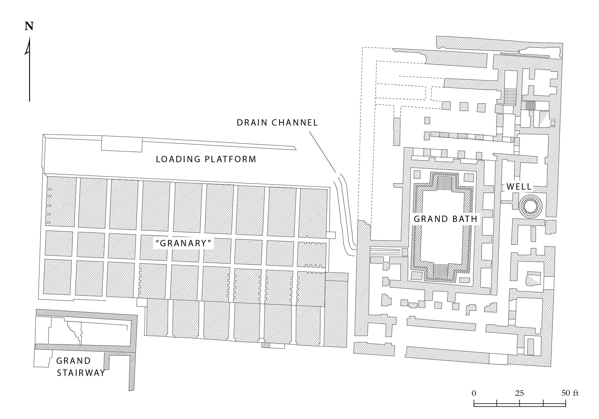
There is still a great deal of mystery surrounding the purpose of these structures. The platform and building were all made from uniformly fired mud brick.
As you may recall from our discussion of the granaries at Bet Yerah, there are two primary means of storing grain: sealed and ventilated. The type of granary at Mohenjo-Daro was probably of the latter variety. It was protected from floods or enemy attack by the large mudbrick platform upon which it was established. The granaries themselves were probably constructed of wood, a material traditionally favored for above-ground granaries due to its ability to breathe and its natural mold resistance.
The granary of a city essentially functioned like a bank. Workers wages were paid in grain rations and taxes were collected in kind. Thus when a Mesopotamian scribe of the Ur III period recorded the amount of grain in a granary, he did not record the volume of grain, but the number of days wages it contained—4020 days.17Wheeler 1964, 25-26 One metric for the health of a city was the amount of grain it held in its stores.


A traditional granary in Slovenia erected on a raised platform to keep the vermin and moisture at bay.
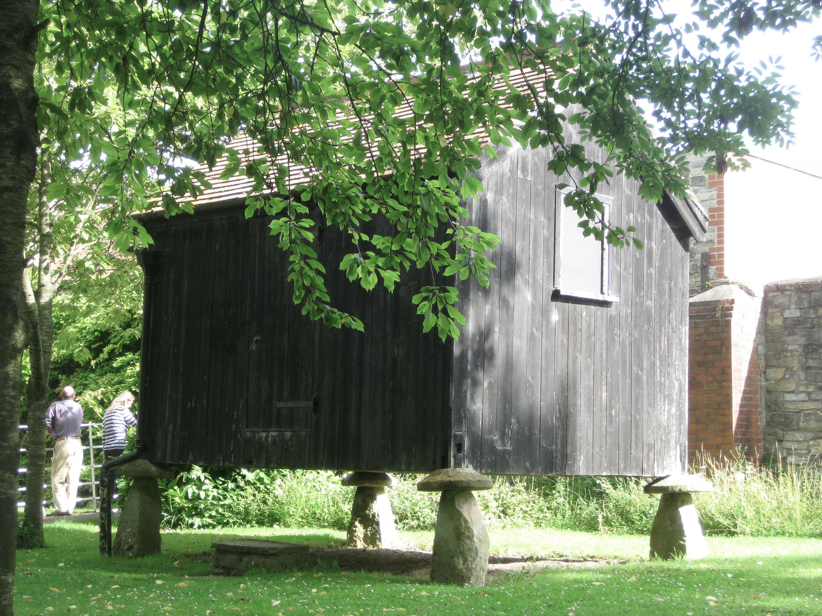

An example of a traditional English granary set on “staddle stones” designed to keep out rodents and allow air to pass beneath the granary floor. There was no need to anchor the granary to its foundation; the weight of the structure being sufficient for that purpose.
Allchin, Bridget, Raymond Allchin.
Origins of a Civilization.
New Dehli: Viking, 1997.
Lal, B. B, S. P. Gupta (eds.).
Frontiers of the Indus Civilization : Sir Mortimer Wheeler Commemoration Volume.
New Delhi: Indian Archaeological Society, 1984.
Marshall, John.
Mohenjo-daro and the Indus Civilization; being an official account of archaeological excavations at Mohenjo-daro carried out by the Government of India between the years 1922 and 1927. Vol. I: Text vols.
New Delhi: Indological Book House, 1973.
Marshall, John.
Mohenjo-daro and the Indus Civilization; being an official account of archaeological excavations at Mohenjo-daro carried out by the Government of India between the years 1922 and 1927. Vole II: Plates vols.
New Delhi: Indological Book House, 1973.
Raikes, R. L.
“Mohenjo Environment,” in Frontiers of the Indus Civilization : Sir Mortimer Wheeler Commemoration Volume, edited by B. B Lal, S. P. Gupta.
New Delhi: Indian Archaeological Society, 1984.
Raikes, Robert L, Robert H. Dyson. “The Prehistoric Climate of Baluchistan and the Indus Valley.” American Anthropologist 63, no. 2 (1961): 265–81. Link
Wheeler, Sir Mortimer.
“The Indus Civilization,” in The Cambridge History of India.
Cambridge: The University Press, 1953.