
The flat-topped, grassy “tell” of Megiddo is clearly visible in the foreground, set against the backdrop of the Jezreel Valley. Visible in the distance at center is Mount Tabor. Nazareth is located in the hills to the left of Mount Tabor while the Gilboa Mountains are visible on the right. The road to Beth Shean, the other major tell in the region, passes through the gap on the right, between the Gilboa Mountains and Mount Tabor.
Perched on a lofty ridge overlooking the vast and fertile Jezreel Valley, Megiddo is one of the oldest and most important cities in the southern Levant. The Jezreel Valley lay at the nexus of several major trade routes that connected Anatolia and Mesopotamia with Egypt. Its strategic location made it the focal point of many ancient battles. Its bloody history was summarized by H.V. Morton as follows:
Virtually every major invader of Israel has had to fight a battle in the Jezreel Valley. Egyptians, Canaanites, Israelites, Midianites, Amalekites, Philistines, Hasmoneans, Greeks, Romans, Byzantines, Muslims, Crusaders, Mamlukes, Mongols, Palestinians, French, Ottomans, British, Australians, Germans, Arabs and Israelis have all fought and died here. The names of the warring leaders who have battled in this small valley reverberate throughout history: Here, in 1479 B.C., Pharaoh Thutmose III fought the first battle in recorded history. Here, too, battled Deborah, Barak and Sisera (Judges 4:1–24, 5:1–31); Gideon conducted the first known night campaign here (Judges 6:3–8:28); and Saul and his son Jonathan fought their last heroic battle in the valley (1 Samuel 28–31; 2 Samuel 1; 1 Chronicles 10). Pharaoh Sheshonq I (c. 945–924 B.C.; probably the biblical pharaoh Shishak), fought here, as did the Israelite kings Jehu and Joram and Queen Jezebel (2 Kings 9:14–37; 2 Chronicles 22:5–9). Later, Antiochus, Ptolemy, Vespasian, Saladin, Napoleon and Allenby fought here. Indeed, the turbulent history of Israel and Judah, Canaan and Palestine, is reflected in microcosm in this blood-soaked little valley.1H.V. Morton, In the Steps of the Master
According to the book of Revelation, the last great battle between good and evil will be fought at “Armageddon.” Many commentators think this name comes from the Hebrew words har megiddo, which means “the mountain of Megiddo,” although other interpretations are also possible.
The Tell
Despite the strategic importance of Megiddo, its exact location was lost for many centuries. It wasn’t until the mid-1800’s that pioneer explorers, armed with an encyclopedic knowledge of languages and geography, began to explore the region with the goal of locating ancient sites. An important means of doing so was name preservation, since the Arabic name of a site often preserves its ancient name. However, Megiddo’s Arabic name, Tell al-Mutesellim (“Hill of the Governor”), bore no relation to its ancient name. Thus when Edward Robinson visited the site in 1852, he noted that the mound offered an excellent view and “would indeed present a splendid site for a city” but discounted the possibility since “there is no trace, of any kind, to show that a city ever stood there.”2Abel 1939, 369 How could this astute scholar have failed to perceive that not only was Tell al-Mutessellim an ancient city but was in fact Megiddo? One reason is that none of the ancient mounds had been excavated in Robinson’s day and were, therefore, still poorly understood.
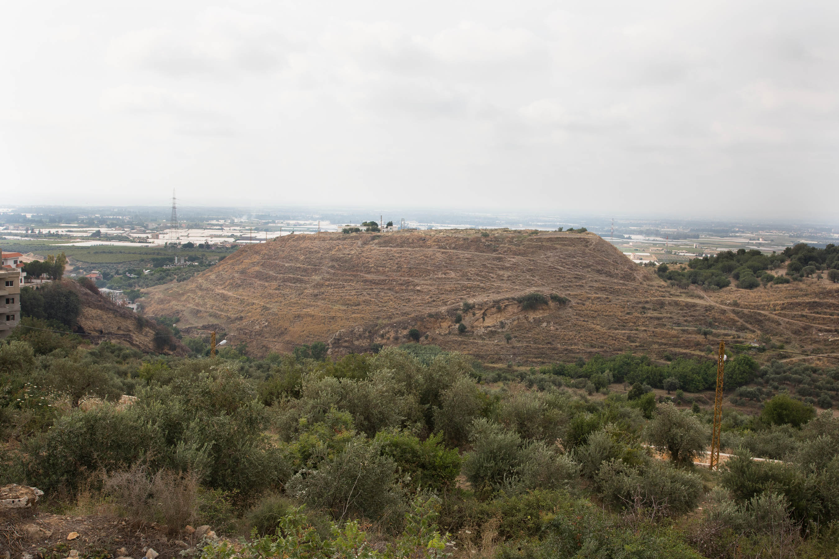
Tell Arqa in northern Lebanon is a classic example of a “tell” or ruin. It may be distinguished from a hill by its flat top, steep sides, and pottery sherds littering its surface. Its Arabic name “Arqa” preserves its ancient name, Irqata, a city mentioned in Akkadian cuneiform texts of the 14th century BC (the Amarna Letters).
It wasn’t until the 1890’s that the first excavations were undertaken in what was then Palestine by archaeologists keen to discover what secrets lay buried in the ancient mounds (Arabic. tell, “mound”). But the tells did not give up their secrets easily. Excavating them proved to be extremely laborious and the results were often difficult to decipher. A tell was not comprised of a single ruined city, but many cities, stacked one top of the other. When a city was destroyed—whether by natural disaster, warfare, or abandonment—it became a layer or “stratum” in the tell. The tell was essentially “a layer cake of ancient cities, one built upon another.”3 James Henry Breasted “The Human Adventure“, a movie produced by the Oriental Institute, 1935 But this cake is badly mangled, like someone took a spoon and dug holes in it, and then scraped the icing off of the top, well… You get the idea.

This model of Tell es-Sultan (Jericho) illustrates three distinct strata in a tell (in actual fact, there were many more strata than this). The square grids superimposed on each stratum illustrates a method of excavating which seeks to systematically expose the architecture and artifacts in a stratum before digging into the next one. This method of dividing the tell into “squares” was pioneered by Sir Mortimer Wheeler and later adopted by Kathleen Kenyon at Jericho.
Excavating Tell al-Mutesellim
Gottlieb Schumacher, a German resident of nearby Haifa, initiated the first excavations at Megiddo from 1903-1905. Further excavations were undertaken by the Oriental Institute of the University of Chicago from 1925-1939 and then by the Hebrew University during the 1960’s and early 70’s. The site is currently being excavated by a team led by Israel Finkelstein, Matthew Adams, and Mario Martin under the auspices of the Tel Aviv University.4The Megiddo Expedition
The early years at Megiddo were met with considerable difficulty due to the unhealthy environment of the region. It is reported that when his Excellency, the High Commissioner, Lord Plumer, visited the site in the 1920’s, there was no one available to receive him since every member of the staff was sick with malaria. Early attempts to deal with malaria involved spraying “Paris Green,” a type of poison made with arsenic, on the swampy areas around the tell in order to kill the malarial mosquitoes.5Fisher 1929, from pg. x of the Introduction The arsenic killed the mosquitoes alright and no doubt more besides. The correct solution was provided by the British corps of engineers who drained the swamp around Megiddo in the late 1920’s.
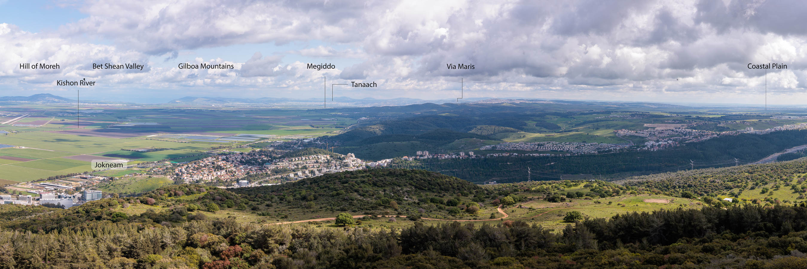
View of the Jezreel Valley looking south from Mount Carmel.
It is not a coincidence that Megiddo is located in a swampy part of the valley. It was undoubtedly water that attracted people to the site in the first place. Megiddo lies on the watershed of the Kishon River. Although only a seasonable stream today, the Kishon was once a perennial river that flowed north through the Jezreel Valley, around Mount Carmel, and then west towards the Mediterranean Sea. Two springs provided Megiddo with a good supply of water.
Speaking generally, a good supply of water was, of course, the most important factor for determining the location of a city, but there were other factors as well which contributed towards the success of a city.
- location on a trade route, navigable river, or natural harbour
- access to arable land and pasture
- availability of wild game and fishing
- natural resources such as metals, precious stones, wood, salt
- defensible location
- a temple or sacred place
Only a very few places in a given region are able to check off all or most of these boxes. Thus when a city was founded, it tended to remain fixed to the same spot for many centuries or even millennia. Megiddo would remain an important city for the next two and a half millennia.
The Canaanites
The emergence of Megiddo as a city in the southern Levant likely coincides with what may be considered the beginning of Canaanite civilization. It is impossible to say for sure since no texts have been found in Canaan from the 3rd millennium BC. The majority of the population probably did speak a West Semitic language in as much as the majority of place names in the region are also semitic.6Aharoni 1967, 11 That being said, there were at least several large incursions of peoples from the north who spoke Indo-European languages.
The region known as “Canaan” is a narrow strip of arable land that runs north-south along the Mediterranean coast. Sandwiched between the desert and the sea, it is only about 60 miles wide and perhaps 350 miles long, from the mountains of Lebanon to the Gulf of Aqaba. Although not very large, the land of Canaan encompasses many diverse ecosystems.
Its lush northern valleys are watered by the rain and snow which falls on Mount Hermon. The meltwater percolates through the porous limestone of the mountain until it hits an impermeable layer of basement rock, thus forcing the water to exit through springs near its base. Two large springs, one at Dan and the other at Banias, and countless smaller ones besides, form the headwaters of the Jordan River.
The river tumbles through thickets of oleander and canebrakes before losing itself in the vast swamp of the Hula Valley formed by basalt flows which partially dam the river. The Jordan nevertheless manages to resume its downward rush through rocky fields strewn with basalt until it reaches the Sea of Galilee. Although not more than thirty miles distant from the snowy peaks of Hermon, which rises 9000 feet above sea level, the Sea of Galilee is a mild and tropical region 600 feet below sea level. Its dark silty soil, produced by the weathering of basalt outcroppings in the area, was well suited for growing all manner of fruits and vegetables. To the fertility of the land may be added the bounty of the sea, the largest body of sweet water in the Levant, which provided habitat for sardines, carp, and tilapia.


Upon exiting the southern end of the Sea of Galilee, the Jordan passes through the Kinrot Plain which is also quite fertile and home to some of the oldest agricultural villages in he world. The climate grows more arid we follow river’s rapid descent into the Jordan Valley. The haunt of lions and bears until Biblical times, the valley was formed by the separation of the African and Arabian plates, resulting in a deep tear in the earth’s crust.
The hills to the west of the Jordan River are made of limestone. The finest stone is known as Meleke (“royal”). It is easy to form into blocks but hardens with exposure to the elements and develops an amber hue. Jerusalem is made of this stone, giving rise to the saying, “Jerusalem, the golden.” The limestone of the central hill country weathers into a fertile, red-brown soil famously known as terra rosa. The hills of this region were already terraced in ancient times for growing olives, figs, and grapes.
The tableland east of the Jordan was well suited for raising herds and flocks and growing grain. The Jordan Valley itself, because it lies so far below sea level, gets almost no rain.


The air grows hot and stale as the Jordan River nears its final resting place, the Dead Sea, nearly one quarter of a mile below sea level (c. -1400 feet). Encompassed about by deep ravines and rocky cliffs, the region has always been a haven for bandits and refugees. The chalky soil produced by the Senonian rock west of the Dead Sea is quite unproductive. Here lies the expansive Judaean wilderness which formed the backdrop for the Parable of the Good Samaritan and the Temptation of Christ found in our New Testaments.
The warmth of the Jordan Valley made it a destination for kings and princes seeking to escape the damp cold of the mountains. King Herod built several winter palaces near the Dead Sea, one of them located amid the date palms and groves of aromatic balsam which grew in the famous oasis of Jericho.


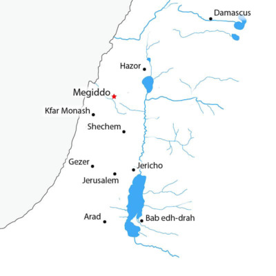
The land of Canaan may be divided lengthwise into four narrow strips of land: the coastal plain, the central mountain range, the Jordan rift, and the Transjordanian highlands.7Aharanoi 1967, 19 There was only one road through this terrain large enough for an army to pass, and this was the Via Maris (“The Way of the Sea”). The Via Maris passed through the Jezreel Valley and thence to Damascus or Lebanon. Megiddo’s strategic position on this trade route meant that, according to the famous warrior king of Egypt, Thutmose III, capturing Megiddo “was like capturing a thousand cities.”
Aharoni, Yohanan.
The Land of the Bible: A Historical Geography, translated by A. F. Rainey.
London and Beccles : William Clowes and Sons, 1967.
Cline, E. H.
Digging up Armageddon : the search for the Lost City of Solomon.
: Princeton University Press, 2020.
Abel, F. M. “Edward Robinson and the Identification of Biblical Sites.” Journal of Biblical Literature 58, no. 4 (1939): 365–72. Link
Fisher, Clarence.
The Excavation of Armageddon.
Chicago: The University of Chicago Press, 1929. Link
Loud, Gordon.
Megiddo II: Seasons of 1935-39, Plates.
Chicago, Illinois: University of Chicago Press, 1948. Link
Loud, Gordon.
Megiddo II: Seasons of 1935-39, Text.
Chicago, Illinois: University of Chicago Press, 1948. Link
Maisler, Benjamin. “Canaan and the Canaanites.” Bulletin of the American Schools of Oriental Research 102 (1946): 7–12. Link
Ussishkin, David.
Megiddo-Armegeddon, The Story of the Canaanite and Israelite City.
Jerusalem: The Israel Exploration Society and the Biblical Archaeological Society, 2018. Link