

The Indus River flowing through a canyon in the foothills of the Himalayas. In the background the westernmost peak of the Himalayas, Nanga Parbat, rises 26,660 feet.
Although not as well known as Egypt or Sumer, the Indus Valley was home to a third great riverine civilization that has its origins in the Early Bronze period. The tributaries of the Indus River are found in the high, snowy peaks of the Himalayas and Hindu Kush. Their names are, from north to south:
- Indus
- Jhelum
- Chenab
- Ravi
- Beas
- Sutlej
- Ghaggar-Hakra(?)
Known in the earliest texts of Hinduism as the “Land of the Seven Rivers,” the Indus and its tributaries flow through the greater part of the Punjab province of Pakistan before combining to form a mighty river which passes for the remainder of its journey through the Sind province of the same country, debouching finally into the Indian Ocean. Here is how Stuart Piggot describes the Sind:
On the river-plain, almost the whole terrain, except for the riverine strips and artificially irrigated areas, is now sandy desert with, at the most, a covering of desert-scrub or small bushy trees such as the tamarisk. The subterranean salt, dragged to the surface by the unimpeded evaporation of such moisture as the soil contains, forms a crust which has been well described as “a satanic mockery of snow.”1Piggot 1962, 67

This map shows the relation of the Indus Valley ancient Elam and Mesopotamia.
Discovery
James Lewis was the first European to provide a written description of the ancient ruins of the Punjab. Having arrived in India as a soldier in the private army of the British East India company, he deserted in 1827 and travelled thenceforth under the alias of an American from Kentucky named Charles Masson. Although his true identity was eventually discovered, his fame as an explorer helped to shield him from reprisals.2Richardson 2022
Masson’s journal preserves tantalizing information about an ancient civilization, previously unknown, which flourished on the banks of the Indus River. In one journal entry he records having visited a place named Harappa where he saw a “ruinous brick castle” on a high mound. Masson noted that the ground was strewn with stone bangles—arm rings—which he thought must have belonged to some ancient civilization.
“The walls and towers of the castle are remarkably high, though, from having being long deserted, they exhibit in some parts the ravages of time and decay… Tradition affirms the existence of a city, so considerable that it extended to Chicha Watni, some thirteen cosses* distant…” (*a coss is a Hindi measurement of length equivalent to approximately 1.8 miles)3Lahiri 2006

The strongly fortified citadel of Harappa.
Dated by Mason to the time of Alexander the Great, he could not have known that this “castle” was actually several millennia older. Harappa turned out to be one of the two principal cities of the Indus Valley Civilization (IVC) that flourished from the middle of the 3rd millennium BC to the middle of the 2nd. It is sometimes also referred to as the Harappan civilization after the city where it was first discovered.
Fortified City
Sir John Marshall was the first archaeologist to excavate Harappa. Sadly, by the time he got there, much of the brickwork visible in Masson’s day had been dismantled and used to lay the bed for a railway line. However, enough of the city was left was left to gain some idea of the massive brick wall which once encompassed the acropolis of the city. The wall was constructed entirely of rectangular, kiln-fired mudbricks laid in regular courses with very little mortar. This method presents a contrast with the style of construction found in Mesopotamia, where fired brick was used sparingly and only for those parts of the wall exposed to the elements. No fired bricks were used in Egypt during the Early Bronze period and only very rare afterward. The use of large quantities of fired bricks at Harappa is therefore unique and must have consumed a lot of labour and energy. The only possible justification, Marshall argued, was that the region must have received an inordinate amount of rainfall at one time, forcing the city builder’s to use materials capable of holding up under heavy rain. Marshall also notes that the production of so many fired bricks would have required ample supplies of wood to fuel the kilns, a resource sorely lacking in the region today. 4Marshall 1973, 266

The city strata (top right) were nestled inside the mudbrick walls of the city (green). The wall itself measured more than thirty feet thick.
The Lost River
When discussing how the environment of a region has changed over the centuries and millennia, we tend to immediately think of climate change. However, tectonic activity may also have played a part, especially in areas located in tectonically active zones, such as the southern Ghor or the Indus Valley. However, if the rift which created the Dead Sea was formed by the separation of two plates, the Himalayas were produced by the collision of the Indian and Eurasian plates. The result was a chain of mountains that rises almost 30,000 feet above sea level. The Dead Sea is essentially the inverse of Mount Everest. The difference, of course, is that the rift is filled with sediment so that the full effect of the separating plates is mostly hidden from view.
It has been suggested that the very forces which form mountains and valleys may also have changed the drainage patterns of rivers so that water which formerly drained into the Ghaggar was captured by the Sutlej and Yamana instead. The Ghaggar ran dry as a result, and the Hakra, which was fed by the Ghaggar. Although it once carried a sizeable volume of water, the Hakra now terminates in the Thar Desert.
This geographical oddity has some bearing on the study of the Indus Valley Civilization since a great many Harappan sites were constructed along the Ghaggar–Hakra channel. Conversely, none have been found on the Sutlej or the Yamuna.5V. N. Misra, “Climate, a Factor in the Rise and Fall of the Indus Civilization: Evidence from Rajasthan and Beyond” in Lal and Gupta (eds.) 1984, 474 Thus suggests to V. N. Misra that during Harappan times, the Yamuna and Sutlej drained into the Ghaggar-Hakra channel.
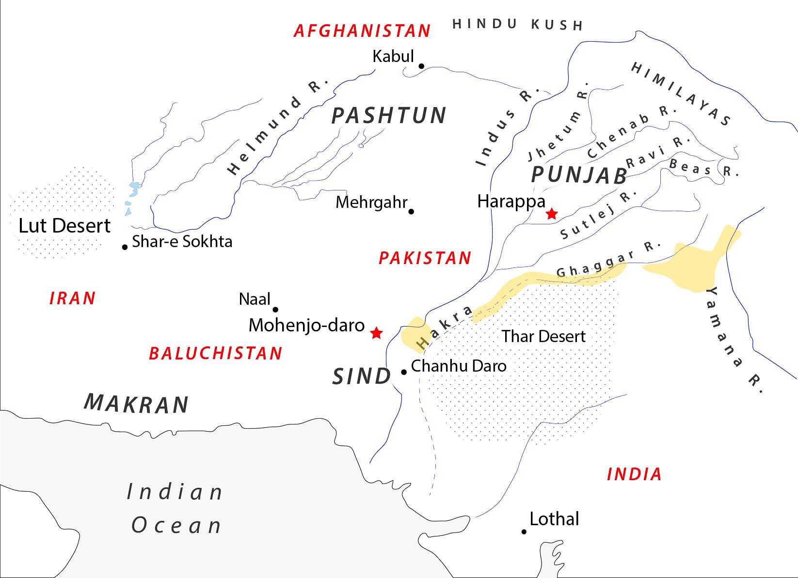
The map shows the location of the Ghaggar and Hakra channels in relation to the Indus River and the Thar Desert. Yellow marks areas of dense Harappan settlement.
It is difficult to conceive of how such a radical change to the topography of a region, enough to reroute a river, could have occurred over the course of less than a millennium. But drastic changes to the landscape of a region may happen in an instant. This was observed by none other than Charles Darwin who was present when an earthquake struck Chile, instantly lifting an island eight feet out of the water and raising the coastline by as much as four feet. This dramatic upthrust of the earth’s crust was the culmination of two decades of more gradual changes that raised the local harbor by four feet.6Dobbs 2011 The east coast of Arabia, which lies on the same fault line as the Dead Sea, seems also to have experienced upthrusts so that Hellenistic settlements which were once situated on the coast are now ten miles inland.7Bibby 1984, 390
That an earthquake caused the Indus River to shift its course was already suggested by the Greek geographer Strabo (63 BC – 24 AD) who cites a report by Aristobulus, one of Alexander the Great’s engineers. Aristobulus saw in India “more than a thousand cities, together with villages, that had been deserted because the Indus had abandoned its proper bed.”8Strabo writes: “And it is reasonable to suppose from his statements that the land is also quite subject to earthquakes, since it is made porous by reason of its great humidity and is subject to such fissures that even the beds of rivers are changed. At any rate, he says that when he was sent upon a certain mission he saw a country of more than a thousand cities, together with villages, that had been deserted because the Indus had abandoned its proper bed, and had turned aside into the other bed on the left that was much deeper, and flowed with precipitous descent like a cataract, so that the Indus no longer watered by its overflows the abandoned country on the right, since that country was now above the level, not only of the new stream, but also of its overflows.” Strabo, “Geography” Book 15,1:19 Strabo attributed this catastrophe to an earthquake which caused the Indus River to change its course. Might Aristobulus have been looking at the dried up channel of the Ghaggar-Hakra and the many Harappan settlements constructed along it? I don’t know.
The earliest Hindu scriptures, the Rigveda, mentions a lost river named the Sarasvati, located somewhere between the Indus and Yamana rivers. It is the only river to have entire hymns dedicated to it in the Rigveda. These hymns refer to the Sarasviti as a mighty river which flowed from the mountains to the sea. However, later Hindu texts describe a peculiar phenomenon; the Sarasvati terminated in the desert at a place known as “the disappearing.” Early scholars thought these texts must refer to the dried up channel of the Ghaggar–Hakra. Sir Aurel Stein, a pioneer explorer in the region, predicted that many ancient sites would be found along its banks, a prediction which proved correct. Indeed, the majority of Harappan sites discovered to date have been found along the Ghaggar-Hakra.
One may reasonably assume that whatever caused the channel to run dry happened in historic times. Thus the Indian geologist, K. S. Valdiya, echoing Strabo, notes that rivers in tectonically active zones are known to move, in some cases by a hundred kilometers or more, over a period of just several hundred years. If this happened to the Ghaggar, then it would explain why Harrapan sites were abandoned along its course.9Valdiya 2013, 50
Another proposal put forward by Giosan et al. (2012) in the Proceedings of the National Academy of Science argues that the Ghaggar–Hakra channel had ceased to flow with a significant river by the end of the last Ice Age (late Pleistocene), some 10,000 years ago, long before Harappan times.10Giosan et al. 2012, E1691 Utilizing advanced ground scanning technology, radiocarbon dating, and optically stimulated luminescence dating, the authors of the paper (15 of them) argue that during the Harappan period the Ghaggar–Hakra channel did not flow with a large Himalayan-born river, formed by the melting snow and rain which fell on the mountains, but a much smaller river fed by seasonal monsoons. Giosan and his fellow researchers nevertheless maintain that the Ghaggar–Hakra did flow with a perennial river during the Harappan period due to higher rainfall in the region but that it withered away due to the increasingly arid conditions which marked the end of the Early Bronze period.11Giosan et al. 2012, E1688
It is not clear (to me) what size of river Giosan envisions the Ghaggar-Hakra to have been during the Harappan period, but presumably it was not very large if it was fed solely by summer monsoons and groundwater seepage. One is led to wonder, therefore, why the Harappans would have chosen to build so many of their settlements on a small river which probably did not flow to the sea, instead of next to a large, Himalayan-born river such as the Indus or one of its other tributaries. It may be argued, as Giosan does, that settlements constructed along a smaller river did not have to deal with the devastating floods produced by larger rivers.12Giosan et al. 2013, 889
However, the Harappans clearly knew how to cope with floods, as did the Egyptians and Mesopotamians, while the advantages of living next to a large river more than compensated for the risks.
- Large rivers can be relied upon to provide a constant and steady supply of water, even during periods of drought.
- Barges and quays may be constructed for the transportation of stone, grain, wood and other bulk commodities.
- A major river offers access to the sea and the wider world.
- Large rivers supply a meaningful amount of fish to the diet.
It is no wonder, therefore, that Mesopotamian and Egyptian cities were always constructed along major rivers. It would be surprising if the Harappans did not do the same. The literary evidence points to the Ghaggar-Hakra channel as the not-so-mythical Sarasvati. If so, then it must have been a large river that flowed to the sea, passing through those regions which are now covered by the sands of the Thar desert.
Allchin, Bridget.
“The Harrapan Environment,” in Frontiers of the Indus Civilization : Sir Mortimer Wheeler Commemoration Volume, edited by B. B Lal, S. P. Gupta.
New Delhi: Indian Archaeological Society, 1984.
Dave, Aditi Krishna, Marie-Agnes Courty, Kathryn E. Fitzsimmons, Ashok Kumar Singhvi. “Revisiting the contemporaneity of a mighty river and the Harappans: Archaeological, stratigraphic and chronometric constraints.” Quaternary Geochronology 29 (2019): 230-235. Link
Liviu, Giosan, Peter D. Clift, Mark G. Macklin, James P. M. Syvitski. “Fluvial landscapes of the Harappan Civilization.” Proceedings of the National Academy of Sciences 109, no. 26 (2012). Link
Giosan, Liviu, Peter D. Clift, Mark G. Macklin, Dorian Q. Fuller. “Sarasvati II.” Current Science 105, no. 7 (2013): 888–90. Link
Lahiri, Nayanjot.
Finding Forgotten Cities: How the Indus Civilization was Discovered.
London ; New York: Seagull, 2006.
Lal, B. B, S. P. Gupta (eds.).
Frontiers of the Indus Civilization : Sir Mortimer Wheeler Commemoration Volume.
New Delhi: Indian Archaeological Society, 1984.
Piggott, Stuart.
Prehistoric India to 1000 B.C.
London: Cassell, 1962.
Richardson, Edmund.
Alexandria: The Quest for the Lost City.
Great Britain: Bloomsbury, 2022.
Valdiya , K. S.Current Science 14, no. 1 (January 2013). Link
Wheeler, Sir Mortimer.
“The Indus Civilization,” in The Cambridge History of India.
Cambridge: The University Press, 1953.