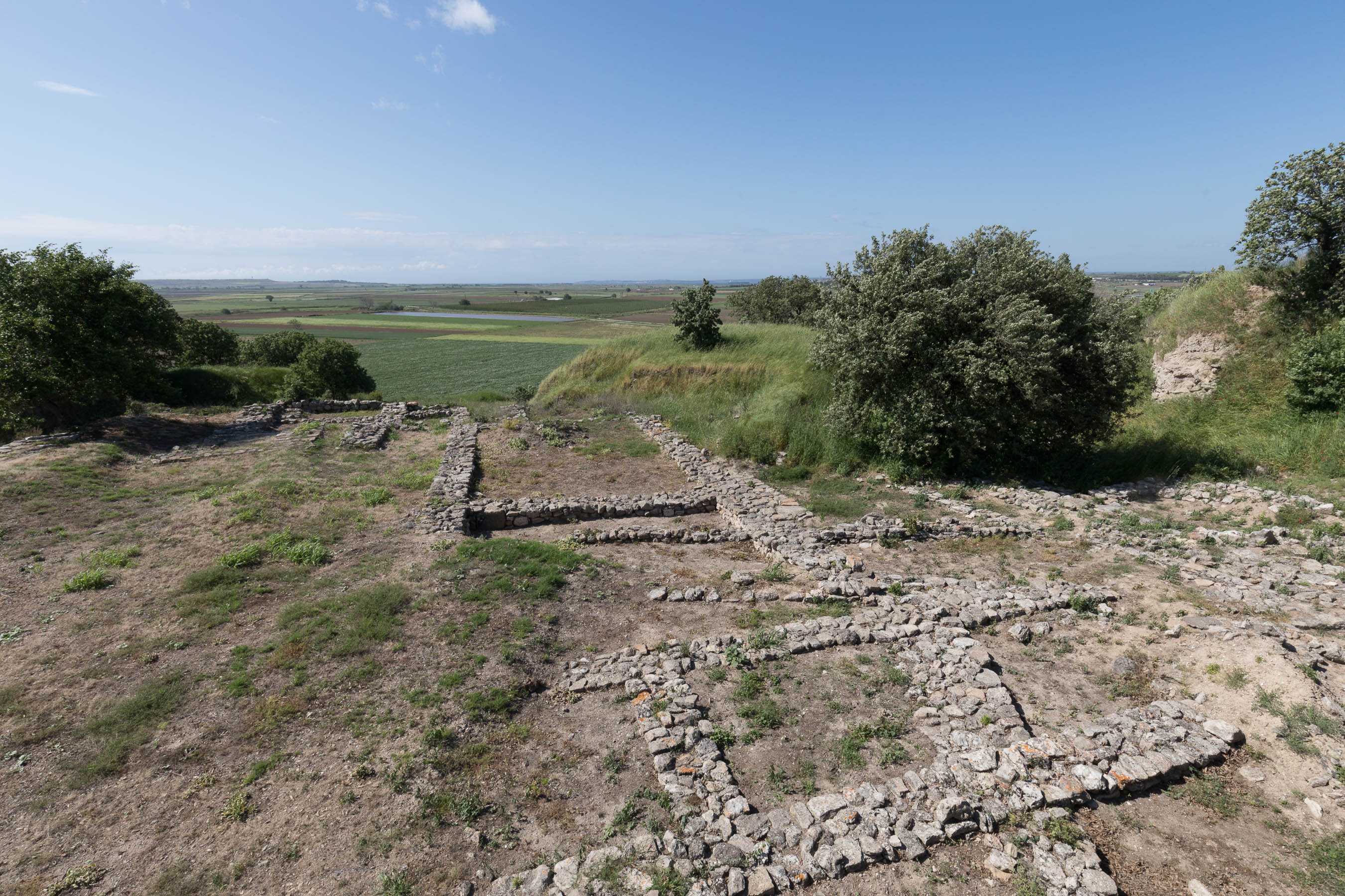
The stone foundations of one of the “megara” on the citadel. In the distance is the coastal plain and the Dardanelles.
Excavations on the highest part of Hisarlik revealed several long, narrow structures named megara (sing. “megaron”) after the Greek term Homer used to refer to the palace. Excavations at other bronze age Greek and Anatolian cities show that this style of architecture was common to the region. The megara were long, narrow structures, with their entrances on the short wall. The entrance was through an attached porch, often flanked by columns. The never share a wall, like a modern townhouse, but were always constructed as standalone structures.
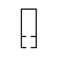
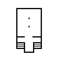
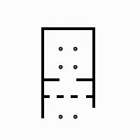
This type of structure was found across the Aegean world during the Bronze Age.
Schliemann would find some particularly fine megaron-type structures on the citadel of Troy II. But this discovery did not come until the very end of his excavations at Troy. Above Stratum II, Schliemann encountered rather flimsy structures which looked like they belonged to a small village perched atop the mound of Hisarlik. Schliemann was looking for the great city described by Homer, with its broad streets and palatial structures. He was therefore puzzled by the maze of streets and small houses he found in Troy III.

The plan of Troy drawn in 1879. Note the houses with flimsy walls, somewhat reminiscent of Kastri.
It was not until the final years of Schliemann’s excavations at Troy (Schliemann died in 1890) that they uncovered the impressive megara structures on the citadel of Troy which belong to Stratum II.
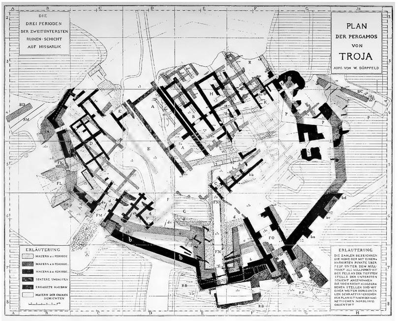
The plan drawn by Dorpfeld (1902) showing Troy II and the large megara structures on the citadel.
The largest megaron (Megaron IIA) measures approximately 34 feet wide by 65 feet long.1The length is more difficult to determine since the entire back of the megaron is missing. Its walls, which were 4 1/2 feet thick, were made of unbaked brick and set on a solid stone foundation. Although almost completely destroyed in the fire which marked the end of Troy II, enough was found inside the structure to reconstruct how it might have looked. There was a round hearth in the middle of the room which would have kept the hall warm during the cold winter months. The outside of the walls of the large central chamber were covered in white plaster. The thatched roof was supported by large beams which spanned the entire width of the structure. An opening in the roof allowed the smoke from the fire to escape and also allowed in some light. Whether the walls had windows or not is impossible determine but they probably did if the buildings depicted on Minoan frescos of a slightly later period (Late Bronze) are any indication.
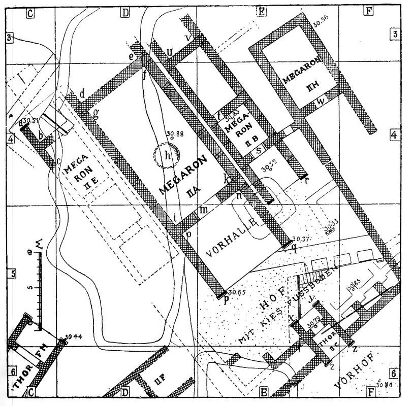
Note how each structure has its own wall rather than sharing a wall.
The mudbricks were unbaked and of a standardized size. Their length to width ratio being such that three bricks laid side by side was equal to two bricks laid end for end. The mudbrick walls were reinforced with embedded wooden beams laid horizontally, every third course. The ends of the walls were capped with a wooden “pilaster” (a half column attached to a wall, also known as an “engaged column”). There is no evidence for supporting pillars inside the building.
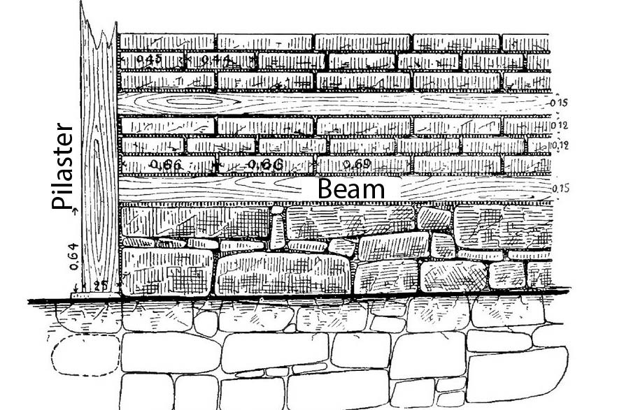
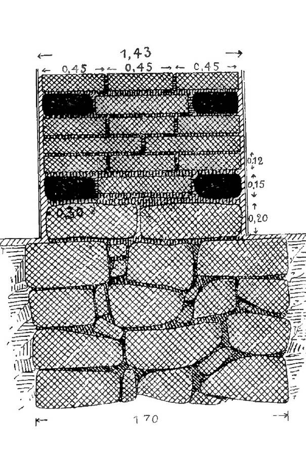
The wall of a megara showing stone foundation for a mudbrick wall reinforced with wooden beams.
What was the purpose for these buildings? Dorpfeld notes that there were too many megaron-type structures on the citadel for them to all have been temples and nothing found in them suggests that they were used as such. He concluded that the megara were the “dwellings of the lord of the castle, his relatives and perhaps his entourage.”2Dorpfeld 1901, Link
Lower City
Although Schliemann uncovered monumental architecture in Troy II worthy of Homer’s description of a Greek palace, he was nevertheless forced to admit that what he found at Hisarlik was really more of a citadel than a city. Although he and his successors thought there must have been a lower city, their small scale probes on the plateau south of the citadel provided only limited evidence of such. The small size of the citadel was one of the primary criticisms leveled against identification of Hisarlik as an important regional capital and the Troy of Homeric fame.
Excavations in the lower city were directed by Manfred Korfmann, who worked at Hissarlik from 1988 until his untimely death in 2005. His dig had significant institutional backing, including from Daimler Chrysler, which enabled him to work for eleven seasons in the lower city and to employ geomagnetic surveys and drill coring to explore the area. Eastman summarizes Korfmann’s discoveries as follows:
The single most important outcome of Korfrnann’s work is the discovery that, throughout the Bronze Age, Troy consisted not just of the small citadel excavated by his predecessors, but included also a substantial lower town spread around it on the plateau to the south and east. This lower town seems to have grown as the citadel grew, so that by the time of Troy VI it extended fully along the plateau to the south.3Donald Easton from the Introduction; Blegen 2005, xxii
Korfmann’s discoveries raised a great deal of controversy, which we will discuss in more detail in our discussion of the Lower City of Troy VI.
In 2001 Korfmann came under fire when he presented his findings in a special exhibit. During an interview with a German radio station, a fellow scholar at Tubingen University, Frank Kolb, dismissed Kormann’s claim to have found an extensive lower city, at one point even going so far as to refer to Korfmann as the “von Däniken of archaeology,” this being the name of a well-known popularizer of alien theories. This incendiary attack on Korfmann’s reputation lit a firestorm in the press. A symposium was arranged at Tubingen to discuss the controversy, which centered primarily on whether there was evidence for a substantial lower city, and the related question of whether Hisarlik was a regional capital or just an isolated castle.
The critics argued that Homer’s Troia is a fiction and that it has no connection with Hisarlik, which in any case, was just a fishing village.4Source
Korfmann’s defenders responded by noting that Troia was not the only or even primary name Homer used to refer to the city, but Ilios, which appears 106 times in the Iliad (the name literally means “poem about Ilios”). All of the geographical indications point to a place on the Hellespont west of the Ida range, south of Phyrgia, and north of Lesbos. There is only one ancient site which lies within these geographical parameters that rises to the status of a city and that is Hisarlik, home of classical Greek temple to the “Ilian Athena,” thus preserving the ancient name for the site. There is no question that the Greeks and Romans thought Hisarlik was ancient Troy. Alexander the Great visited Ilion in order to offer sacrifices to the ancient heroes of that place, as did the Roman general…
However, there is much older textual evidence which suggests that this city was the center of an important regional power during the Late Bronze Age. A clay tablet from Hattusa records a treaty made between the Hittite king Muwattalli and Alaksandu, the king of Wilusa. The Hittite text dates to the 13th century BC and thus approximately to . A Hittite treaty has been recovered which names a certain king of Wilusa named Alaksandu. It is generally agreed that this is the Greek name, Alexandros, which also appears in the Iliad for one of the princes of Troy more popularly known as Paris. Whether the two can be equated or not, the important takeaway is that Wilusa was clearly perceived to be a major regional power during the Late Bronze period. Furthermore, the archa
This city can only be identified with Stratum VI-VII of Hisarlik. Hisarlik cannot have been just a “shabby little settlement” as Kolb described it, although archaeology has only been able to uncover a fraction of what once existed.
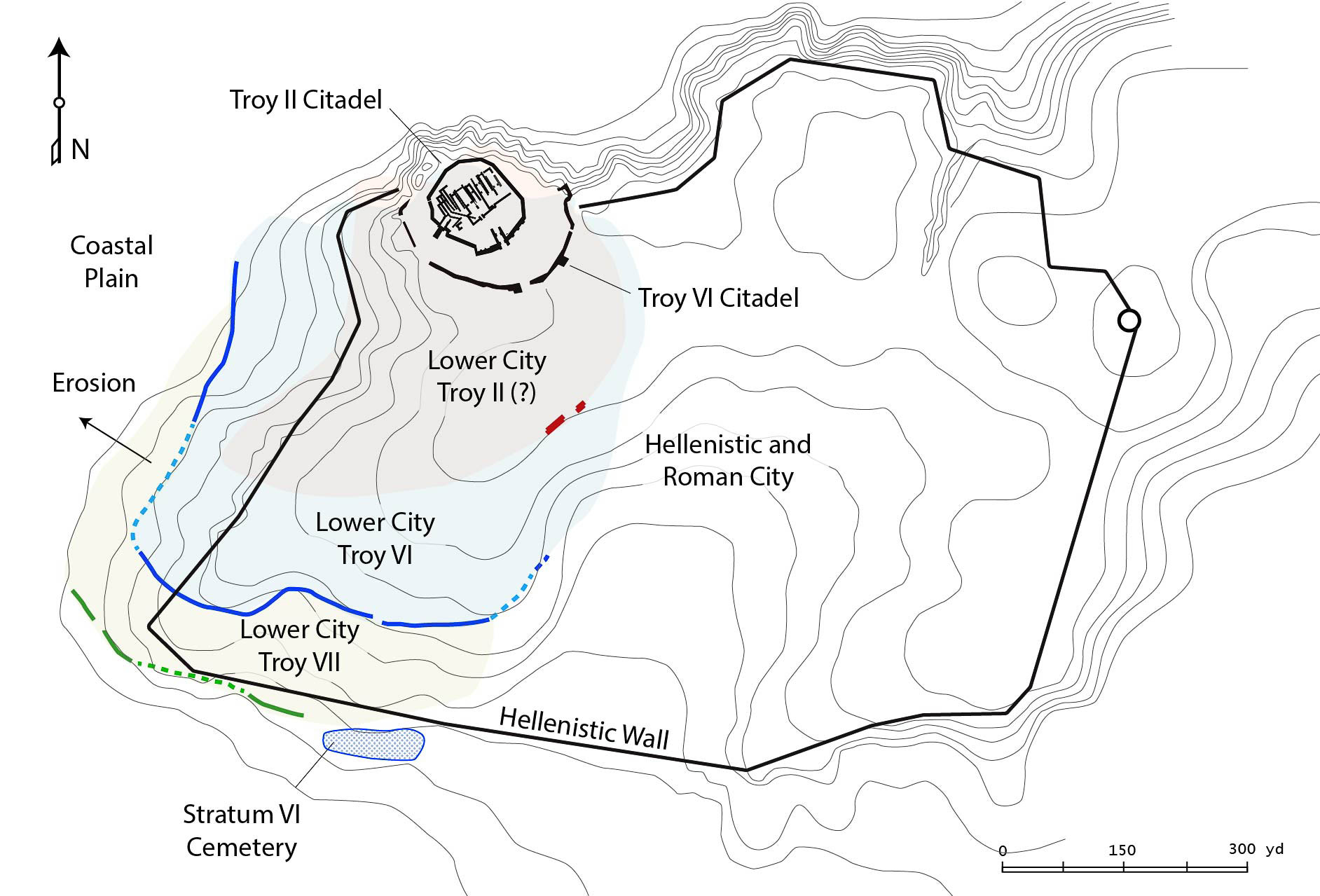
The citadel of Troy in relation its lower city and the walls of the city constructed there during the Hellenistic period.
To the literary evidence may be added some of the discoveries made by Korfmann and his associates in the area around the citadel. Drill coring conducted on the plain west of Hisarlik has shown just how radically the landscape has changed over the centuries. Sediment carried by the Scamander and Simoeis rivers eventually filled the lagoon next to the city and pushed the shoreline further and further away, until the city was surrounded by a fertile alluvial plain instead of the sea. Drill cores in the valley brought up pottery sherds at depths of 30 or more feet below the present day surface.5Kayan 2014, 712-713) Although the sherds are too small to be dated, their existence at these depths points to the amount of sediment which has accumulated on the Scamander plain in historic times. Some of this sediment was deposited by the river (alluvial) whereas the rest was washed off the surrounding hills (colluvial). The effects of erosion are particularly evident on the plateau south and west of the citadel, where Korfmann located the lower city. Only pockets of material from the Late Bronze Age have been found, the rest having either eroded away or been robbed for stone by builders who came after. The entire plateau south of the citadel was covered by a city during the Hellenistic and Roman periods. By then most of the soil had eroded away so that the foundations of Roman houses went right down to bedrock. In some instances, even the bedrock was cut away. Thus not only were the Late Bronze levels (Troy VI-VII) of the lower city lost, but very little of the Hellenistic and Roman (Augustan) cities has survived either.5Easton et al. 2002, 89-91
Korfmann nevertheless found some indications of a lower city which existed on the plateau during the Late Bronze Age. The use of ground scanning technology revealed a series of ditches which appear to mark the outer limits of the city. Subsequent excavations in these areas revealed a ditch 13 feet wide by 8 feet deep cut from the bedrock.6Easton et al. 2002, 87
There are good reasons to think that it was used as part of a defensive work which encompassed the lower city, although its exact nature is uncertain. It is likely that the stone removed during the excavation of the moat was used to make a wall, although nothing of it remains. However, fine Mycenean pottery was found in the ditch which must have originated in the lower city during the Late Bronze period.
The discipline of archaeology can only be applied to what has survived. Unfortunately, in some instances, nothing much remains. Although the discoveries made recently on the plateau are impressive, the strongest proof that Wilusa / Ilios was an important city comes not from archaeology but from the texts themselves which refer to it as such.
Schaeffer, C. F. A.
+++ Schaeffer, C. F. A – Xe et XIe Campagnes de Fouilles a` Ras Shamra-Ugarit (Automne et Hiver 1938-1939) : Rapport Sommaire.
Paris: P. Geuthner, 1941.
Blegen, Carl.
Troy and the Trojans.
London: The Folio Society, 205.
Dörpfeld, Wilhelm.
Troja und Ilion I.
Athen: Beck & Barth, 1902. Link
Easton, D. F., J. D. Hawkins, A. G. Sherratt, E. S. Sherratt. “Troy in Recent Perspective.” Anatolian Studies 52 (2002): 75-109. Link
Smithsonian Magazine. Beck & Barth. October 15, 2024. Link
Kayan, İlhan.
“Geoarchaeological research at Troia and its Environs,” in Studia Troica Monograph 5, edited by Ernst Pernicka, Charles Brian Rose, Peter Jablonka.
Bonn, Germany: Dr. Rudolph Habelt GMBH, 2014. Link
Korfmann, M.
“Troy: Topography and Navigation,” in Troy and the Trojan War: A Symposium Held at Bryn Mawr College, October 1984, edited by J. L Angel, M. J. Mellink.
Bryn Mawr, Pa: Bryn Mawr College, 1986. Link
Müller, Valentin. “Development of the ‘Megaron’ in Prehistoric Greece.” American Journal of Archaeology 48, no. 4 (1944): 342–48. Link
Schliemann, H.
Troy and its Remains; A Narrative of Researches and Discoveries Made on the Site of Ilium, and in the Trojan Plain.
London: J. Murray, 1875. Link
Dorpfeld, Wilhelm.
Troy and Ilium: Results of the Excavations in the Prehistoric and Historic Layers of Ilium, 1870-1894 .
Athens: Beck & Barth, 1902. Link